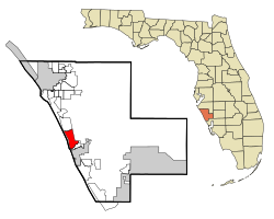
Laurel, Florida
Laurel, Florida | |
|---|---|
 Location in Sarasota County and the state of Florida | |
| Coordinates: 27°8′29″N 82°27′44″W / 27.14139°N 82.46222°W[1] | |
| Country | |
| State | |
| County | Sarasota |
| Area | |
| • Total | 10.18 sq mi (26.38 km2) |
| • Land | 9.08 sq mi (23.52 km2) |
| • Water | 1.10 sq mi (2.86 km2) |
| Elevation | 10 ft (3 m) |
| Population (2020) | |
| • Total | 12,186 |
| • Density | 1,341.92/sq mi (518.13/km2) |
| Time zone | UTC-5 (Eastern (EST)) |
| • Summer (DST) | UTC-4 (EDT) |
| ZIP code | 34272 |
| Area code | 941 |
| FIPS code | 12-39600[3] |
| GNIS feature ID | 0285395[4] |
Laurel is a census-designated place (CDP) in Sarasota County, Florida, United States. The population was 12,186 as of 2020 census.
Laurel is part of the North Port–Sarasota–Bradenton Metropolitan Statistical Area.
Geography[edit]
According to the United States Census Bureau, the CDP has a total area of 6.1 square miles (15.8 km2), of which 5.1 square miles (13.2 km2) is land and 0.97 square miles (2.5 km2), or 16.13%, is water.
Demographics[edit]
| Census | Pop. | Note | %± |
|---|---|---|---|
| 2010 | 8,171 | — | |
| 2020 | 12,186 | 49.1% | |
| U.S. Decennial Census[5] | |||

As of the 2020 United States census,[6] the population of Laurel was 12,186 with 5,572 households resulting in a persons per household rate of 2.02.
By age, the population was split with 2.8% under 5 years old, 12.5% under 18 years old, and 42.1% 65 years and older. 50.2% of the population were female persons. By race, the population was split with 88.9% white, 2.8% black, 0.3% American Indian and Alaska Native, 2.5% Asian, 3.5% two or more races, and 2.3% Hispanic or Latino. There were 1,193 veterans and 10.6% of the population were foreign born persons.
The owner-occupied housing rate was 84.9%. The median value of owner-occupied housing units was $338,200. The median selected monthly owner costs with a mortgage was $2,051 and the median selected monthly owner costs without a mortgage was $590. The median gross rent was $1,569. 94.9% of households had a computer and 90.0% had a broadband internet subscription. The median household income was $69,850 and the per capita income for 12 months was $48,053. 6.3% of the population lived below the poverty threshold.
96.3% of the population 25 years and older were high school graduates or higher and 39.2% of that same population had a Bachelor's degree or higher.
Notable people[edit]
- Vivian E. Browne, visual artist
References[edit]
- ^ "US Gazetteer files: 2010, 2000, and 1990". United States Census Bureau. February 12, 2011. Retrieved April 23, 2011.
- ^ "2020 U.S. Gazetteer Files". United States Census Bureau. Retrieved October 31, 2021.
- ^ "U.S. Census website". United States Census Bureau. Retrieved January 31, 2008.
- ^ "US Board on Geographic Names". United States Geological Survey. October 25, 2007. Retrieved January 31, 2008.
- ^ "Census of Population and Housing". Census.gov. Retrieved June 4, 2016.
- ^ "QuickFacts Laurel CDP, Florida". United States Census Bureau. Retrieved April 17, 2023.

