
Sousel
Sousel | |
|---|---|
 Flag .png) Coat of arms | |
 | |
| Coordinates: 38°57′N 7°40′W / 38.950°N 7.667°W | |
| Country | |
| Region | Alentejo |
| Intermunic. comm. | Alto Alentejo |
| District | Portalegre |
| Parishes | 4 |
| Government | |
| • President | Manuel Valério (PS) |
| Area | |
| • Total | 279.32 km2 (107.85 sq mi) |
| Population (2011) | |
| • Total | 5,074 |
| • Density | 18/km2 (47/sq mi) |
| Time zone | UTC±00:00 (WET) |
| • Summer (DST) | UTC+01:00 (WEST) |
| Local holiday | Easter Monday date varies |
| Website | http://www.cm-sousel.pt |
Sousel (Portuguese pronunciation: [soˈzɛl] ⓘ) is a municipality in the District of Portalegre in Portugal. The population in 2011 was 5,074,[1] in an area of 279.32 km2.[2]
The municipality is famous for its olive trees and as a great hunting region.
The Calça e Pina family was the main developer of Sousel in the 18th century. The economy is mainly based on agriculture, but tourism plays a major role in the region's economy as well.
The present Mayor is Manuel Valério, elected by the Socialist Party. The municipal holiday is Easter Monday.
Parishes[edit]
Administratively, the municipality is divided into 4 civil parishes (freguesias):[3]
- Cano
- Casa Branca
- Santo Amaro
- Sousel
Notable people[edit]
- Bruno Bolas (born 1996) a Portuguese professional footballer
Gallery[edit]
-
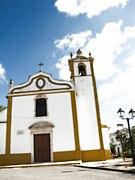 Local church.
 -
 Distinctive Alentejano chimney.


References[edit]
- ^ Instituto Nacional de Estatística
- ^ Áreas das freguesias, concelhos, distritos e país
- ^ Diário da República. "Law nr. 11-A/2013, page 552 117" (pdf) (in Portuguese). Retrieved 31 July 2014.
External links[edit]
| International | |
|---|---|
| National | |
This Portalegre location article is a stub. You can help Wikipedia by expanding it. |