
Les Chenaux Regional County Municipality
Les Chenaux | |
|---|---|
 | |
| Coordinates: 46°30′N 72°25′W / 46.500°N 72.417°W[1] | |
| Country | |
| Province | |
| Region | Mauricie |
| Effective | January 1, 2002 |
| County seat | Saint-Luc-de-Vincennes |
| Government | |
| • Type | Prefecture |
| • Prefect | Gérard Bruneau |
| Area | |
| • Total | 934.40 km2 (360.77 sq mi) |
| • Land | 872.04 km2 (336.70 sq mi) |
| Population | |
| • Total | 17,865 |
| • Density | 20.5/km2 (53/sq mi) |
| • Pop 2006-2011 | |
| • Dwellings | 8,393 |
| Time zone | UTC−5 (EST) |
| • Summer (DST) | UTC−4 (EDT) |
| Area code(s) | 819, 418 or 581 |
| Website | www |
Les Chenaux (meaning the channels in French) is a regional county municipality in central Quebec, Canada, in the Mauricie region. The seat is in Saint-Luc-de-Vincennes. It is located adjacent on the east of Trois-Rivières on the Saint Lawrence River. It has a land area of 872.04 square kilometres (336.70 sq mi) and a population of 17,865 inhabitants in the Canada 2011 Census.[4] Its largest community is the parish of Notre-Dame-du-Mont-Carmel.
Les Chenaux is one of the few regional county municipalities in Quebec that does not constitute its own census division; instead, it is grouped with Trois-Rivières as the single census division of Francheville.

Geography[edit]
The "Les Chenaux" RCM is an area east of Trois-Rivières, located between the villages of Champlain and Sainte-Anne-de-la-Pérade on north shore of St. Lawrence River. The MRC is approximately 40 km in length to about 20 kilometers in depth. The territory is crossed by three rivers flowing from north to south: Champlain River, Batiscan River and Sainte-Anne River.
History[edit]
The RCM was created in 2002, when the area was realigned to make way for the amalgamations of nearby Trois-Rivières and Shawinigan. All of the municipalities, except for Notre-Dame-du-Mont-Carmel (which came from Centre-de-la-Mauricie RCM), used to belong to the former Francheville Regional County Municipality. This RCM was dissolved when six of its municipalities amalgamated with the city of Trois-Rivières, and Saint-Étienne-des-Grès was added to the Maskinongé RCM. The remaining municipalities were grouped into a new regional county called Les Chenaux.
Subdivisions[edit]
There are 10 subdivisions within the RCM:[2]
|
|
Demography[edit]
| Municipality | Status | Area | Population (2006) |
Density |
|---|---|---|---|---|
| Batiscan | Municipality | 44,02 km2 | 937 hab. | 21,3 inhabitants/km2 |
| Champlain | Municipality | 58,59 km2 | 1 583 hab. | 27,0 inhabitants/km2 |
| Notre-Dame-du-Mont-Carmel | Municipality of parish | 126,61 km2 | 5 300 hab. | 41,9 inhabitants/km2 |
| Sainte-Anne-de-la-Pérade | Municipality | 107,94 km2 | 2 145 hab. | 19,9 inhabitants/km2 |
| Sainte-Geneviève-de-Batiscan | Municipality of parish | 97,09 km2 | 1 125 hab. | 11,6 inhabitants/km2 |
| Saint-Luc-de-Vincennes | Municipality | 52,73 km2 | 613 hab. | 11,6 inhabitants/km2 |
| Saint-Maurice | Municipality of parish | 90,33 km2 | 2 308 hab. | 25,6 inhabitants/km2 |
| Saint-Narcisse | Municipality of parish | 103,49 km2 | 1 852 hab. | 17,9 inhabitants/km2 |
| Saint-Prosper | Municipality | 92.03 km2 | 555 hab. | 6.0 inhabitants/km2 |
| Saint-Stanislas | Municipality | 86,37 km2 | 1 077 hab. | 12,5 inhabitants/km2 |
| Total | 859,20 km2 | 17 495 hab. | 20,4 inhabitants/km2 |
Transportation[edit]
Access routes[edit]
Highways and numbered routes that run through the municipality, including external routes that start or finish at the county border:[5]
|
|
Photos[edit]
- Land of running water and countless lakes
-

-

-
 Saint-Narcisse, Lac-à-la-Tortue bog
 -
 Saint-Maurice (Quebec), Au Lard River, agricultural zone
 -
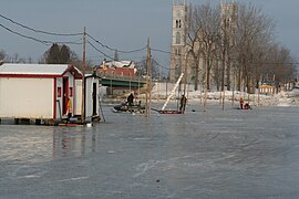 Sainte-Anne-de-la-Pérade, Ste-Anne river, the installation of the winter fishing village
 -
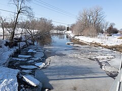
 Saint-Prosper-de-Champlain, rivière Charest, tributary of the Sainte-Anne River
 -

-
 Champlain, Champlain River near its mouth
 -
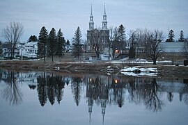 Saint-Stanislas, Batiscan River, Parish church, presbytery, municipality


-Belv%C3%A9d%C3%A8re_au_parc_nature-Tourbi%C3%A8re_de_St-Narcisse-2022-10-02.jpg)


See also[edit]
- List of regional county municipalities and equivalent territories in Quebec
- Lordship of Sainte-Anne-de-la-Pérade
- Lordship of Batiscan
- Lordship of Champlain
References[edit]
- ^ "Banque de noms de lieux du Québec: Reference number 375747". toponymie.gouv.qc.ca (in French). Commission de toponymie du Québec.
- ^ a b c "Répertoire des municipalités: Geographic code 372". www.mamh.gouv.qc.ca (in French). Ministère des Affaires municipales et de l'Habitation.
- ^ a b 2011 Statistics Canada Census Profile: Francheville (Stats include City of Trois-Rivières figures)
- ^ a b c Derived indirectly by subtracting the data for Trois-Rivières census subdivision from the data for Francheville census division (view side-by-side).
- ^ Official Transport Quebec Road Map
Adjacent Counties & Equivalent Territories | |
|---|---|
| Regional county municipalities and equivalent territories | |
|---|---|
| Municipalities | |