
Talk:Jesusland map
| This is the talk page for discussing improvements to the Jesusland map article. This is not a forum for general discussion of the article's subject. |
Article policies
|
| Find sources: Google (books · news · scholar · free images · WP refs) · FENS · JSTOR · TWL |
| Jesusland map received a peer review by Wikipedia editors, which is now archived. It may contain ideas you can use to improve this article. |
| This article was nominated for deletion on 10 December 2009 (UTC). The result of the discussion was keep. |
| This article was nominated for deletion on 17 December 2009 (UTC). The result of the discussion was keep. |
| This article is rated C-class on Wikipedia's content assessment scale. It is of interest to multiple WikiProjects. | ||||||||||||||||||||||||||||||||||||||||||||||||||||||||||||||||
| ||||||||||||||||||||||||||||||||||||||||||||||||||||||||||||||||


untitled[edit]
At what point is an Internet meme too ephemeral to merit an article? I think this one's real close -- I doubt very much we'll see this anywhere (other than a "tired jokes" forum) after another week or so. Jwrosenzweig 23:23, 12 Nov 2004 (UTC)
Then let's wait a week and see, shall we? In the meantime, I think the article is admirably done. (My main objection is to the recycling of the mildly interesting but gimmicky notion of meme, but that's another issue.) Hoary 23:28, 12 Nov 2004 (UTC)
- Oh, I do agree the article is well done! But I have my doubts about whether or not articles like this will open a floodgate of perhaps lower quality articles. Regardless, though, I'm happy to wait a week or much longer to see if this is a good move for Wikipedia or not -- I do credit the authors here, though, with writing an article good enough to be a serious treatment of a really rather silly image. :-) Jwrosenzweig 23:37, 12 Nov 2004 (UTC)
- Thank you very much. You are correct; the whole concept is a bit, well, lightweight, but the meme itself is spreading rapidly and is the subject of serious discussions. I have heard (second-hand) that it was briefly discussed on The McLaughlin Group and touched on in an article in the Washington Times. Given that exposure, I decided to write the article. - Scooter 03:54, 13 Nov 2004 (UTC)
The idea that some states have more in common with Canada than the rest of the union is not something new nor is it limited to internet jokes. While this is an interesting article (as it stands now it gets my stamp of approval), it would be interesting to conduct additional research (perhaps including the often raised idea that in the case of a split of the Canadian confederation, the middle provinces might join the US). Although it might sound extreme to most moderate/mainstream hears, a reshuffle of the Canadian and US provinces and states has often been mentioned in more or less serious papers - although certainly more serious than the image at hand. Anyway bravo for the article. --Phils 15:32, 14 Nov 2004 (UTC)
- Thank you! - Scooter 16:12, 15 Nov 2004 (UTC)
I've reverted the change by User:Ed Poor. It wasn't grammatically correct, for one, and the concept of a meme is well-established on Wikipedia (see Nevada-Tan, for example) and in the study of memetics. It's a sociological construct; calling it a "gimmick" (as above) doesn't really do it justice. - Scooter 22:47, 23 Nov 2004 (UTC)
seems awfully opinionated....is this real enough to merit a WikiPedia? I think it merits itself on some humor site but I thought Wikipedia was a resource for historical research. Christain bashing is becoming an art. If this were the middle east and it was Allah land they'd pull it down for fear of riots in France.
"Bush Country" map is irrelevant and inaccurate[edit]
It has nothing at all to do with this topic....
Subject for Delete[edit]
The origin of this is from the blog of former Dean campagin members at CivicSpace Labs. Now, my concern is practical here. The Jesusland map was a blogger's invention, that has been spread primarily through other internet blogs. Other satirical graphics can be found on blogs for Bush, Dean, Kerry, and Nader, and we can find blog satire on politics, technology, music, and television shows. Is Wikipedia going to be a storing house for blogger's cartoons? Do we want to add the "Dan Rather Credibility Flowchart"? Wikipedia is definitely not a blog, and this sort of thing sets a precedent for every bit of satire and wit created on the countless blogs on there and their equally countless topics. Unless Wikipedia is to be a storehouse for blog humor, this is completely inappropriate. --Corwin8 08:04, 3 Dec 2004 (UTC)
- Do you have a source for the fact that this comes from Dean campaign members? If so, let's add it. - Scooter 03:08, 7 Dec 2004 (UTC)
- To follow up on my own post: the source given in a previous revert is CivicSpace, according to a "Robert Eriksson", and an anonymous user on Slashdot, according to a follow-up poster. I think it'll have to remain "unknown" until we can come up with something better. - Scooter 20:00, 8 Dec 2004 (UTC)
The meme was created by G. Webb, a poster on a UK-based message board - an interesting wrinkle on this story. The source (in the form of a message-board thread where it was first posted) is now cited in the article. He appears to have been somewhat shy of garnering publicity on this, but it's important that Wikipedia gets even the small details right! (Sorry, don't have a user account, but around 8:20pm UK time, 9 Feb 2005)
Why do you consider it just "blog humor"? Why did the idea spread outside the blog? What is the signal it gives? Pure joke, are you sure? Or something more basic and serious? Why should Wikipedia blind itself to what happens in society? Now you can make it even more known by launching one of those weird Wikipedia VfD debates, certainly one of the best advertising tool in town, success guaranteed, maybe it is your purpose after all :-)) --Pgreenfinch 08:25, 3 Dec 2004 (UTC)
The signal it gives? It's O.K. to spam Wikipedia. Pure joke? Of course it is. Something more basic and serious? No. Wikipedia blind itself to what happens in society? Society seems unchanged to me. Well, I'm assuming that you were honestly ignorant of the answers to your questions, so I've answered them for you (oh, this is my first Wikipedia talk). Satisfied? --Corwin8 09:17, 3 Dec 2004 (UTC)
I thought you were a psychologist. Maybe in your studies you missed the chapter about cognitive dissonance, or some milder forms such as underreaction (I might write this last article, but no problem if you do it first ;-)). --Pgreenfinch 09:59, 3 Dec 2004 (UTC)
If he were a psychologist, wouldn't he be much more interested in how individuals and communities express their fears and outrages to perceived negative changes in their environment? Perhaps that's merely anthropology. Regardless, the metric of "if it isn't on network TV, it isn't notable" isn't the prevailing measure of worthiness here. The point is moot; whether or not this concept results in a change to society doesn't indicate it's validity. It's one of a number of expressive reactions to a major political event that has had much resonance in many circles, mostly online. By nature, a meme must be notable, else it wouldn't be a meme. Even if it is only an Internet meme. - [[User:KeithTyler|Keith D. Tyler [flame]]] 01:58, Dec 6, 2004 (UTC)
This is more than just a blogger's graphic. It captured and came to personify the popular disenfranchisement and alienation two halves of a country's population. This is not a map, it's a cultural schism put into graphics, and it is entirely deserving of its own article space. Unlike the red state blue state divide which is an event and a concept, this map has given it a distinct form that American society can relate to. People are still remembering this map, as it was remembered in anger, gloating and frustration. Its presentation of humor has been a popular katharsis in this visceral national event. It must stay. - Gilgamesh 03:21, 6 Dec 2004 (UTC)
To suggest that there is neither redeemable encyclopedic value in documenting the "Jesusland map", nor significant attention to the concept to justify this page is ridiculous. At a minimum, thousands of people are aware of, and were affected in some way by it, and this is a quality article. If we deny articles on the basis of their subjects being spread only by the Internet, then Wikipedia itself does not deserve an article. It must stay. -- Eric 08:25, 6 Dec 2004 (UTC)
- Again, thank you. My basis for writing it was that it did appear to be spreading to multiple forms of media, as I mentioned above. Do people feel it would make the article stronger if I could cite the dates and articles in the Times and McLaughlin Group? - Scooter 03:08, 7 Dec 2004 (UTC)
- Why don't we readjust it for the results of the 2008 election? —Preceding unsigned comment added by 70.174.35.241 (talk) 00:04, 23 April 2009 (UTC)
Bigotry vs. pride[edit]
On the comment that the map was considered "religious bigotry", I checked Google with the terms "Jesusland" and "bigotry" and ended up with 991 hits. They seemed slightly in favor of those saying that the concept was bigoted; some said that those in "Jesusland" were bigoted. However, a Google search on "Jesusland" and "proud" as terms yielded 9210 hits. About the same percentage as above gave some indication of "proud to be from Jesusland"; some expressed pride that they weren't. Based on that, I decided to list those who were proud along with those who thought the concept was bigoted, as the latter seem to be in the minority. - Scooter 04:34, 7 Dec 2004 (UTC)
History is littered with people taking insults up and wearing them as badges of honor. As for religious bigotry, you might try asking a priest or minister or two what they think. I have no doubt that left or right leaning they would find the concept offensive for two reasons: 1. "Jesusland" has plenty of sinners. 2. The United States of Canada has plenty of Jesus followers.
It's bigoted.
12.190.79.238 08:28, 14 October 2006 (UTC) Whoops, wasn't logged in, here I am again TMLutas 08:29, 14 October 2006 (UTC)
I also agree that the map is bigoted in nature, it's stereotyping the entire population of each state simply by how many electoral votes went to one candidate or another. The past American presidential elections have shown (as the Purple America map does) that Americans are not so easily divided, yet this map contributes to an intolerant, prejudiced mentality based simply on where one lives.
Speaking of which, I've reverted an edit made earlier this year in February by an anonymous user with the IP 76.24.183.243 which changed "United States of Canada" to "United States of Liberty & Education." Putting aside the fact that the original thread referenced in this article clearly shows that this is not the name originally used on the map, this piece of anonymous vandalism is even more offensive than the map itself, as it outright claims that religion and education are mutually exclusive.
I'm surprised that, for all of Wikipedia's reputation in scouring articles to fight wiki vandals, no one batted an eye at the inclusion of such an offensive vandalizing edit for all these months hence. 65.67.180.37 (talk) 22:36, 1 December 2011 (UTC)
Rename[edit]
Only the first two paragraphs of the article specifically reference the Jesusland map(s). The last paragraph also references it, but its contents would also apply equally to other post-election division maps.
The remaining three paragraphs discuss other maps that are not the Jesusland map or make statements that apply to all such maps.
Suggest moving this article to one with a more generic topic that would include all such post-election division maps, something like Protest maps of the 2004 U.S. election.
- [[User:KeithTyler|Keith D. Tyler [flame]]] 23:34, Dec 13, 2004 (UTC)
- I think the "Jesusland map" is the title which most people will be searching on. I haven't really heard names dedicated to the others with any real regularity. Perhaps we could redirect Jesusland, Jesusland map, etc., to your protest maps link when such terms grow in popularity? - Scooter 05:19, 19 Dec 2004 (UTC)
Removal of cleanup tag[edit]
I don't think, based on the above comments and the recent editing, that this article needs to be listed under "Cleanup". This appears to be motivated by something other than a wish for good copyediting. I've commented on it here and have removed the Cleanup tag. - Scooter 21:51, 29 Dec 2004 (UTC)
Lexicon entry?[edit]
I have removed the sentence "...and has entered the lexicon of typical American and Canadian pop culture references." because I doubt it and would like to see a source of that claim first. --Conti|✉ 17:42, Apr 13, 2005 (UTC)
[1] should do you (from the new [Ben Folds] album).
Political colo(u)rs[edit]
One thing to watch when discussing "red state"/"blue state": in Canada the political colours are opposite. Conservative-Blue, Liberal-Red, NDP-Orange.
- In the United States I believe state coloration is based on which party is incumbent, not on the conservatism or liberalism of each party. -Silence 21:17, 16 December 2005 (UTC)
- Uh, no, I believe 'blue state' = Democrat, and 'red state' = Republican. This is at least what I got out of various comments like "Vermont is a blue state." This is best explained at Red state vs. blue state divide. --Saforrest 07:17, 19 December 2005 (UTC)
- Since this was based on the U.S. election, noone cares about Canada OR it's "coloUrs" ;) 68.39.174.238 06:02, 30 December 2005 (UTC)
- Actually, most of the countries in the world associate red with left-wing politics and blue with right-wing politics, the United States being one of the few exceptions. Not that any of this matters for the scope of this article... —Gabbe 23:16, 26 January 2006 (UTC)
- That's how it used to be in the U.S. as well, until the 2004 election. One news agencies arbitrarily chose red for republican and blue for democrat, and happened to have the most-cited map. -- Phyzome is Tim McCormack 21:08, 20 April 2006 (UTC)
- That's so not true. In the United States, Red has always meant Republican and Blue Democrat. If you want to talk Conservative and Liberal, the Red and Blue colors hold their meaning going back to 1960. --Solid South
- What's amusing is that the well-researched article completely contradicts that statement. - Keith D. Tyler ¶ (AMA) 19:45, 3 July 2006 (UTC)
- That's so not true. In the United States, Red has always meant Republican and Blue Democrat. If you want to talk Conservative and Liberal, the Red and Blue colors hold their meaning going back to 1960. --Solid South
- That's how it used to be in the U.S. as well, until the 2004 election. One news agencies arbitrarily chose red for republican and blue for democrat, and happened to have the most-cited map. -- Phyzome is Tim McCormack 21:08, 20 April 2006 (UTC)
Canada[edit]
The 2006 canadian election saw BC, SK and MB join AB in going completely ga-ga Conservative, so this would seem to question the inclusion of those provinces in Bluestatistan. Admittedly CDN conservativism isn't the same as USA Republicanism, and the reasons behind the shift may or may not be ideological, but it's still a rightward shift in party support. And Conservative wasn't CDN's only viable alternative to the Liberals. - Keith D. Tyler ¶ (AMA) 20:04, 10 April 2006 (UTC)
- Did the voters shift to the right or did the party shift to the center? ;) heqs 09:11, 21 June 2006 (UTC)
- BC, Sasketchewan and Manytubas all elected non-Conservatives MPs - only Alberta and Prince Edward Island went entirely for one part. BC, Sask. and Man. are not nearly as Conservative as Alberta, especially historically. Albertans have been off the right wing diving boards since at least the 1930s, whereas Sasketchewan is the home of medicare, and so forth. WilyD 13:17, 7 July 2006 (UTC)
- Especially B.C. In Provincial elections B.C. has often voted for left leaning parties, votes for the Conservatives are much more of a reaction against the Federal Liberials, than any indication of support in Conservative/Jesus Land values Travis 23:52, 25 July 2006 (UTC)
- Manitoba and Saskatchewan both currently have left of centre NDP governments. In all provinces other that Alberta the CConservatives still polled less than half the vote, even though they had a plurality, and in most cases, the combined vote of the centrist Liberals and leftist NDP is larger than the Conservatives. I think it is drawing a long bow to say that Canadians have suddenly become conserative. Also, the issues that the CDN Conservatives campaigned on were different to the issues that conservative republicans campaign on.
- Following up on that last post, it's a given in Canadian politics, especially in Ontario and in the West, that the three-way split between main parties means that NO party is gone "ga ga" for, but rather what appears to be a sweep of the vote is really only a sweep of the seats. A plurality of votes means that a seat can be won with as little as 34% of teh vote, and commonly about 37; 40 is considered a landslide. If it came down to a vote on annexation and if only right/left were the factor, there'd be no association between current governing seats and the results of that vote; anti-annexation sentiment is very strong in Canada, and particularly among the left, and the centre, and many in the right; nationalism/patriotism are much stronger than mere left-right political sentiment. Even Alberta has a strong non-right contingent to its vote, just not enough to win provincial elections or many federal seats; it doesn't mean t hat they're not there. Jesusland and the 51st state arguments/campaigns like to ignore this set of facts. Religiosity is also not as entrenched in the right in Canada as it is in the US; if it were a question of a biblically-ruled republic that was the annexing party, there'd be little support IMO, other than among Canadian fundamentalists, and they are not as numerous, even among hte right, as they are in the US. The large multicultural contingent in all four provinces would also reject a Christian-themepark republic out-of-hand..Skookum1 (talk) 15:42, 3 April 2009 (UTC)
- Manitoba and Saskatchewan both currently have left of centre NDP governments. In all provinces other that Alberta the CConservatives still polled less than half the vote, even though they had a plurality, and in most cases, the combined vote of the centrist Liberals and leftist NDP is larger than the Conservatives. I think it is drawing a long bow to say that Canadians have suddenly become conserative. Also, the issues that the CDN Conservatives campaigned on were different to the issues that conservative republicans campaign on.
- Especially B.C. In Provincial elections B.C. has often voted for left leaning parties, votes for the Conservatives are much more of a reaction against the Federal Liberials, than any indication of support in Conservative/Jesus Land values Travis 23:52, 25 July 2006 (UTC)
- Remember, if it isn't about improving the article, it doesn't belong on this talk page. Cheers, CapnZapp (talk) 21:54, 9 April 2009 (UTC)
Why is Canada on the map?[edit]
As a Canadian citizen I find this extremley offensive. Canada is a sovreign nation, not just some US state. You could have just omitted Canada like you did Mexico.
You do realize that it's just a matter of time til Canada is absorbed into the US.
Maybe not this decade, or the next, but sooner than you think.
Why? Canada has 30 million people, the US has 300 million people. A ten to one advantage. Retrieved from "http://en.wikipedia.org/wiki/Talk:Jesusland_map"
--PEAR 14:08, 31 August 2006 (UTC)
- The point is that some regions of the US are so liberal, they might as well be Canadian, or at least they're much closer to Canada politically. ::sighs:: Less paranoia, please. —Nightstallion (?) 13:21, 5 September 2006 (UTC)
I Agree - the point is that the blue states would like to join Canada rather than be a part of the rest of the reliogiously influenced country. No offence was meant or should be taken.
-As a Californian, I abbreviate my state as: CA. And I know that Canadians abbreviate their nation as: CA. So if California was absorbed by Canada, and I lived in the city of La Cañada, I could write my address as: La Cañada, CA, CA.
Canada cannot absorb California as Californian population is 36 million while Canada´s population is 33 million. And the Californian economy is about 20% larger than the Canadian. The blue states would have about 130 million people while the red states would have about 190 million people... —Preceding unsigned comment added by 79.146.210.74 (talk) 21:06, 1 September 2008 (UTC)
- Not everyone in Canada is a brain-dead liberal you know. I'm a Canadian and I consider American liberals to be some of the most disgusting and despicable people on Earth, Canadian liberals have many redeeming qualities, but American liberals are just self-hating baby-killing idiots. Not to say that I dislike Americans, American conservatives are great people. --RucasHost 03:17, 18 August 2007 (UTC)
- Excuse me, please try to excercise more discretion when deciding whether or not to call someone a self-hating baby-killing idiot. Thank you. Calgary 05:27, 18 August 2007 (UTC)
- Why, it's what they are? Anyway, you must be one screwed up dude to choose the username "Calgary" when you've never been to Canada. "First item on the docket, despite what the username may lead you to believe, I am not Canadian, nor am I associated with Canada in any way. I've never even been to Canada. Don't get me wrong, I'm sure it's a lovely country, I'm just not the sort of person who visits places very often." --RucasHost 09:48, 18 August 2007 (UTC)
- I'm sorry, perhaps I didn't make myself clear. It's also generally a good idea to exercise discretion before attempting to vocalize how screwed-up you believe your fellow Wikipedians to be. Thank you. Calgary 21:29, 18 August 2007 (UTC)
- Why, it's what they are? Anyway, you must be one screwed up dude to choose the username "Calgary" when you've never been to Canada. "First item on the docket, despite what the username may lead you to believe, I am not Canadian, nor am I associated with Canada in any way. I've never even been to Canada. Don't get me wrong, I'm sure it's a lovely country, I'm just not the sort of person who visits places very often." --RucasHost 09:48, 18 August 2007 (UTC)
- Excuse me, please try to excercise more discretion when deciding whether or not to call someone a self-hating baby-killing idiot. Thank you. Calgary 05:27, 18 August 2007 (UTC)
- Not everyone in Canada is a brain-dead liberal you know. I'm a Canadian and I consider American liberals to be some of the most disgusting and despicable people on Earth, Canadian liberals have many redeeming qualities, but American liberals are just self-hating baby-killing idiots. Not to say that I dislike Americans, American conservatives are great people. --RucasHost 03:17, 18 August 2007 (UTC)
- Also, I'd have thought that Canadians would know that Calgary is a Scottish name. I've been there, and I've never been to Canada. :) . . dave souza, talk 13:06, 8 October 2007 (UTC)
- Canada only wants Minnesota, Michigan and Massachusetts where hockey is played and loved. Geez, let's get our facts right, unlike RucasHost who decided to personally attack a whole host of americans. OrangeMarlin Talk• Contributions 13:52, 8 October 2007 (UTC)
Technically this is more nationalistic to Canada, it GIVES us all the blue states of the US, and they become provinces, thus the government in such a country would be centred in Ottawa still and it'd still be Canada. -Anonymous Canadian —Preceding unsigned comment added by 24.244.192.130 (talk) 17:57, 23 May 2008 (UTC)
You realize that in this map, Canada is the superior nation state? (Hence "United States of Canada, instead of "New America" or "Liberal States of America) —Preceding unsigned comment added by 24.226.56.226 (talk) 18:17, 16 February 2009 (UTC)
- Why is Canada on the map? Because that's how the original artist created it, that's why. That does not mean in the slightest that Wikipedia is making some sort of statement. Best Regards, CapnZapp (talk) 21:53, 9 April 2009 (UTC)
Canadian Election Map[edit]
Some took out the 2004 Canadian election which was helpful in illustrating the critique of the map based on assuming Canadian is just one big block of Democrats. Unless someone can give me a damn good reason why not, I'm putting it back in. After all there are about a dozen maps of the US that it is compared to in the article. One Canadian one wouldn't hurt. Kevlar67 20:12, 25 October 2006 (UTC) In canada, even our conservatives are semi liberal. i think it paints sask in a bad light, seing as provincially we usually elect a socialist government 216.197.255.21 05:03, 23 October 2007 (UTC)
A part needs removing[edit]
I've found this in the first paragraph of the article "This page is a flamitory remark towards Democrates and should be elimunated. Wikipedia is sick for alowing this page to operate." I know THAT isn't supposed to be there, but it doesn't seem to show up in the "edit this page" function. Sorry if i sound like an idiot...
Hmm... it's not there anymore... I guess it was edited out WHILE I was viewing the page. Problem solved then.
Mistake in 2004 electoral college map[edit]
The map has hawaii as a red state. 65.119.109.3 17:36, 14 April 2007 (UTC)
Specification in Israeli parallel[edit]
Which conservative religious group?
There is no need for Israel to be included in this discussion as this pertains exclusively to North America. Otherwise it can be argued that Conservative/Liberal division exist throughout the world (i.e. France, Brittain, Australia...). —Preceding unsigned comment added by 99.246.18.177 (talk) 14:34, 3 October 2007 (UTC)
Original[edit]
What happened to the Jesusland map. I don't even see it on the page. I see other irrelevent ones. Would somebody please put it back on the page. —The preceding unsigned comment was added by Jgatesy (talk • contribs).
- The copyright police managed to get it deleted from Wikipedia. Maybe someone can obtain a version that's free to use here?
- Atlant 16:52, 4 June 2007 (UTC)
- I'm getting really fed up with the copyright fascism on this site at the moment. This article is ridiculous without a map on it. I think I'm gonna go make one now. — OwenBlacker 14:15, 10 June 2007 (UTC)
Physical versions[edit]
I added a small section on physical versions (clothes etc). Unfortunately I could only find commercial sites as proof of this. if anybody knows of news articles mentioning this development of the meme, please replace the commercial refs with them. Totnesmartin 14:07, 26 October 2007 (UTC)
Deletions[edit]
I deleted a fair volume of material from the article on the grounds that it was unsourced and possibly non-NPOV. User:Atlant reverted me, arguing that the criticisms were "likely to be correct." That's certainly a good thing, but the standard for inclusion is and has always been verifiability, not correctness. Deltabeignet (talk) 00:18, 9 December 2007 (UTC)
well that's wrong, and it sucks. wikipedia needs to decide if it wants to be a wiki or an encyclopedia. it can't be both. —Preceding unsigned comment added by 69.125.110.223 (talk) 19:55, 17 December 2007 (UTC)
- Huh? Wikipedia has always known it "wants to be" an encyclopedia, where facts are verifiable. For a wiki containing random rumors (to put it charitably), I suggest you check out Uncyclopedia instead. Have a nice day. CapnZapp (talk) 12:46, 7 November 2008 (UTC)
Bad recreation[edit]
Whoever "recreated" the map did a bad job at it -- Here's the original: http://web.knoxnews.com/silence/archives/jesusland.jpg The colors are vastly different, the names are missing, and there are lines between the states when in the original the only lines are the borders of the whole countries. The original made the point in very emphatic visual way -- the "recreation" just fails at it.
So right now the recreation is no recreation at all. More like the shadow of the shadow of one.
I'd try to correct it, but have zero experience with SVG images. Aris Katsaris (talk) 18:41, 26 February 2008 (UTC)
USC flag?[edit]
I've seen a United States of Canada flag around before in two different variations, one shows a Canadian flag with a star and the other shows a US flag with a Maple leaf. Why haven't one of these been posted along with the Jesusland flag? —Preceding unsigned comment added by 24.244.192.130 (talk) 18:10, 23 May 2008 (UTC)
Washington D.C.[edit]
It's small, so it's hard to tell, but in the map currently on this article, Washington D.C. is shown as part of Jesusland. It voted for Kerry, so I suspect it should be part of the US of Canada. - Shaheenjim (talk) 05:51, 22 June 2008 (UTC)
- Not just for Kerry - it is the bluest part of the US, having voted Democrat in every election since it was allowed to. Timrollpickering (talk) 18:38, 23 August 2008 (UTC)
Alaska[edit]
I'm not sure how to phrase it or where it would go in the article, but perhaps something should be said for the oddity of including Alaska in "Jesusland" despite it being one of the least religious states in the U.S. See: Unchurched Belt, Alaska#Religion —Preceding unsigned comment added by Jomasecu (talk • contribs) 00:06, 23 September 2008 (UTC)
- It's included because it is a predominantly conservative state, not because of religion. The jesusland map is based off the 2004 election, not the religiousness of the states. Hope that helps. Zombie Hunter Smurf (talk) 00:19, 23 September 2008 (UTC)
- Yeah, I understand that, but the red area is obviously named for the implied association between conservatism and Christianity. Jomasecu (talk) 01:00, 23 September 2008 (UTC)
- Well that is true, hence "Jesusland", but we probably can't make such a comment without a source pointing this out. Zombie Hunter Smurf (talk) 01:16, 23 September 2008 (UTC)
- Yeah, I understand that, but the red area is obviously named for the implied association between conservatism and Christianity. Jomasecu (talk) 01:00, 23 September 2008 (UTC)
Recreation of map[edit]
First, how come the original map isn't here? Didn't we get permission to use it, or what?
Second, I request that the "recreation" is re-made. The current recreation loses out much of the immediate humor of the original map. Specifically:
- 1) It attempts to use official colors, rather than trying to mimic the colors of the original
- 2) It attempts to superimpose the original map idea onto a real state-divided map, rather than following the original's feel of being "a quick sketch".
All in all, much of the impact of the original map is lost. Instead we have something that looks faintly scientific or official. Put simply, the joke is gone.
Couldn't we simply have as a picture a snap-shot of the original as it first appeared? Something like this: http://i257.photobucket.com/albums/hh205/kazapp/jesusland.jpg
CapnZapp (talk) 13:14, 7 November 2008 (UTC)
Decreased visibility of the Jesusland flag.[edit]
I moved the Jesusland flag lower on the page, as to not draw attention away from the main subject of the article. Now it doesn't show up when first reaching this page (on a decent-sized browser window, at least), which is what I feel is appropriate. After all, the article isn't about the flag. CapnZapp (talk) 13:20, 7 November 2008 (UTC)
www.newjesusland.com & "update" section[edit]
I reverted the section on a purported "update" of the map (as depicted on the above website). As it stood, the new section was all but indistinguishable from an attempt to draw traffic to a web site. I did not find any resemblance between the original map and those of the web site.
I'm not saying it was, only that it could be. To avoid being reverted in the future, please add more context such as: What connects this site to the original map? Is it by the original author? Can you find mentions in independent media? Essentially, what makes this web site notable, as opposed to being merely an attempt to cash in on a fad? Regards, CapnZapp (talk) 10:04, 11 November 2008 (UTC)
Auster novel[edit]
Good call, Zombie Hunter Smurf. Probably the section needs to go, but sure, give the community a chance to find a referenced connection. Do remember to clean out the Jesusland mention from the novel's page too, if and when that's appropriate. CapnZapp (talk) 10:31, 17 December 2008 (UTC)
- Thanks. I figure if that after a month goes by and no one has found any cites we can delete the info. Zombie Hunter Smurf (talk) 13:11, 17 December 2008 (UTC)
Pop culture section[edit]
Can someone find cites for some of the items in the list? Its dangerously close to becoming rampant with OR. Zombie Hunter Smurf (talk) 14:02, 5 January 2009 (UTC)
perhaps a pop culture reference could point to U.K. author Richard Morgan's use of Jesusland as an area of U.S.A. after a future secession. It's an area that contains a population who hold extreme right wing views, bigotry, racism and anti abortionists all encompassed by their faith. its also a place that becomes a dumping ground of other countries unwanted problemsPix6 (talk) 20:33, 13 April 2010 (UTC)
lol[edit]
Only Wikipedia can disseminate a meme so much it becomes incredibly unfunny. —Preceding unsigned comment added by BLaafg (talk • contribs) 03:18, 9 January 2009 (UTC)
Conservative Censorship of Wikipedia[edit]
This was removed from the Jesusland article:
The term "Dumbfuckistan" came from the cartoon "Blue Christmas" that aired on December 18, 2004, as a TV Funhouse cartoon on Saturday Night Live[1]. In the cartoon "Blue Christmas", Santa skips the states that re-elected George W. Bush and hangs out with liberal celebrities like Margaret Cho, Al Franken, and Moby. "Dumbfuckistan" is now a very popular term in US culture. Often depicted on many U Tube videos are the fictional characters known as Dumbfuck and Stan. "Dumbfuck" is US slang for a stupid person.
Reference
http://mediasluts.blogspot.com/2004/12/drunken-weekend-lotsa-oc.html Media Sluts: Drunken Weekend, Lotsa O.C<!
125.162.168.156 (talk) 10:33, 15 January 2009 (UTC)
- The episode is already referenced in the article and we really don't need to go into the plot. The YouTube videos and the blog are non notable, but if you can find a reliable source we may be able to expand on the variation of the map. Zombie Hunter Smurf (talk) 20:40, 15 January 2009 (UTC)
hahaha conservative censorship of WIKIPEDIA!?!?!? That'll be the day. - 138.163.106.71 (talk)
Seriously??[edit]
This is an old internet meme. Wikipedia is not an archive of old internet memes. I would like to see this "article" deleted. Brianski (talk) 11:56, 27 June 2009 (UTC)
- Actually, it achieved wide mainstream media coverage in late 2004, and was understood as conveying political commentary. It's far above the typical dancing hampster webpage type of thing in inherent notability (and even the dancing hampsters seem to have an article)... AnonMoos (talk) 20:17, 27 June 2009 (UTC)
I agree with deleting it. —Preceding unsigned comment added by 141.189.251.1 (talk) 18:31, 23 November 2009 (UTC)
- On what basis? The AfD (see here and here) pretty much established notability... AnonMoos (talk) 20:37, 13 April 2010 (UTC)
this is not an internet meme, this is purely an American meme. I'd be surprised if you could find anyone outside of the U.S. and Canada who had heard of it. I only stumbled across this page while looking at the damage caused by a blocked user. From the article, it sounds like this map only received notoriety because it was reported on news channels. The whole concept of an internet meme is that it achieved its popularity on the internet, not on news channels. Since it was meant to exist as a joke, the joke is now finished and it's time to remove this page. Owen214 (talk) 02:59, 1 August 2010 (UTC)
- "I'd be surprised if you could find anyone outside of the U.S. and Canada who had heard of it." Well, it received pretty wide didstribution in the UK, and I got it in Malaysia... Wavy (talk) 11:12, 22 September 2010 (UTC)
I clearly remember distributing this to a friend after the 2000 election. So while it might not have gotten huge until 2004 and the election results were similar, I think you should research the history a bit more as this meme started after the first time Bush was elected in 2000 when he proudly called "jesus" his hero during the debates and so forth. — Preceding unsigned comment added by 99.103.0.205 (talk) 06:53, 15 October 2012 (UTC)
Interesting, even outside from its own origin[edit]
I first searched for "Jesusland" after reading Richard Morgan's "Black Man" book (in a French edition, the term is kept untranslated). Never heard of that meme before. This makes more pertinent and relevant the persistence of this item in Wikipedia, to me, as it's being integrated in today's culture. — Preceding unsigned comment added by Wwp (talk • contribs) 14:59, 8 July 2011 (UTC)
Current Map[edit]

shows current state of the construct. Agree that working the meme by updating is contrary to wikipedia rules. 72.228.190.243 (talk) 09:08, 21 November 2012 (UTC)
- i.e. updating the main map in this article, as the meme stands now. Could be useful in another article/later. 72.228.190.243 (talk) 11:59, 21 November 2012 (UTC)
Lesser Jesusland, Real America, Dumbf***istan, whatever it's called[edit]
Not unrelated to the topic immediately above is this and the question of how to integrate it. A related area, sometimes called "The Real America"[2] is somewhat smaller and less contiguous but characterized by a high coincidence among the states on maps of poverty, ignorance, disease, mental illness, certain cultural markers, and right-wing politics making them appear to be manifestations of the same thing. -
- ^ Media Sluts: Drunken Weekend, Lotsa O.C
- ^ Georgia Logothetis, 22%, Daily Kos, Nov 05, 2008.
- Poverty
Poverty in the US - http://en.wikipedia.org/wiki/File:US_Poverty_Rates.svg
Food hardship - http://www.azfoodbanks.org/images/uploads/food-hardship-us%20map%2008-09.jpg
Income inequality - http://upload.wikimedia.org/wikipedia/commons/f/f5/Gini_Index_US_Counties_2010.jpg
Confederacy of takers - http://media.economist.com/sites/default/files/imagecache/original-size/20110806_WOM959_0.gif
- Ignorance
Completed high school - http://3.bp.blogspot.com/-HKLnU_vSVSo/T431bTXg6_I/AAAAAAAABOY/HZ9uMDMUNUM/s1600/educationmap2.jpg
Physical inactivity - http://www.cdc.gov/features/dsphysicalinactivity/dsphysicalinactivity_b410px.jpg
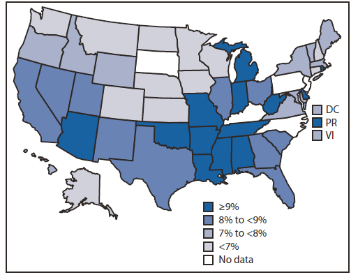
- Disease
Cancer - http://ocw.alfaisal.edu/OcwWeb/Health-Sciences-and-Technology/HST-950JFall-2005/CourseHome/index.htm
Hypertension - http://www.cdc.gov/dhdsp/data_statistics/fact_sheets/images/fs_bloodpressure.jpg
The "stroke belt" - http://wildiris4.securesites.net/cms_prod/files/course/444/stroke_map.gif
Diabetes - http://notunlikeresearch.typepad.com/.a/6a0133f1fb8812970b014e89d296b1970d-pi
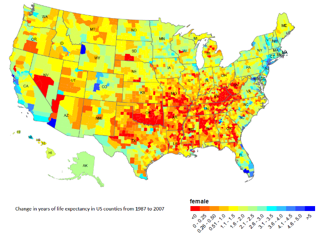
Female life expectancy - http://blogs.nature.com/spoonful/files/LSWoMan2.bmp
Heart disease in white males - http://s42.photobucket.com/user/compoundf/media/CVDcopy.jpg.html
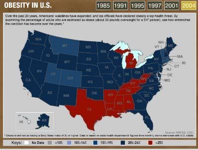
Obesity - http://i42.photobucket.com/albums/e311/compoundf/obesity2004.jpg
- Mental Illness
Mental illness - http://www.cdc.gov/mmwr/preview/mmwrhtml/figures/su6003a1f1.gif
"Sadness Belt" - http://www.alternet.org/environment/where-are-countrys-least-happy-and-healthy-americans-new-studies-reveal-americas-sadness
- Cultural Markers
Ancestry - http://en.wikipedia.org/wiki/File:Census-2000-Data-Top-US-Ancestries-by-County.svg
Baptists - http://www.valpo.edu/geomet/pics/geo200/religion/baptist.gif
Weak "open container" laws - http://en.wikipedia.org/w/index.php?title=File:USA-open-container-law-path2006-2.svg&page=1
"Dry" counties - http://en.wikipedia.org/wiki/File:Alcohol_control_in_the_United_States.svg
- Right-wing Politics
Balanced budget amendments - http://www.demandbalancenow.com/
No Medicaid expansion - http://www.commonwealthfund.org/Maps-and-Data/Medicaid-Expansion-Map.aspx
Hate groups - http://en.wikipedia.org/wiki/File:Number_of_hate_groups,_by_state,_per_million_inhabitants..png
2012 red states - http://en.wikipedia.org/wiki/File:ElectoralCollege2012.svg
New secession states - http://www.google.com/search?q=new+secession+states+map&hl=en&safe=off&tbo=u&tbm=isch&source=univ&sa=X&ei=N-2jUOPwGo-02AX7y4DgDA&sqi=2&ved=0CGEQsAQ&biw=1024&bih=668
Derntno (talk) 19:03, 13 May 2014 (UTC)
- you seem to be inserting your own research into the article, supported by a large number of refs. One problem is doing so is synthesis, WP:SYNTHESIS. For such a short section it should need only one or two references, not dozens. Another problem is (as far as I can tell) the references are not on 'Jesusland map' so off topic. Finally many are not proper references at all: WP cannot be used as a source for itself, nor can images, while blogs and advocacy sites are not usually reliable sources. I don't see any that counts as a reliable source.--JohnBlackburnewordsdeeds 19:23, 13 May 2014 (UTC)
- Yes, I was going to say much the same thing as JohnBlackburne. You're taking all these images and datasets, looking at them, and then claiming that it's related to the political division that is lampooned in the subject of the article. The problem is that you're the one making that claim, which is not enough; if this were to be inserted into the article, we would need a reliable source to make that claim. To do otherwise would be to engage in synthesis of sources into a new proposition that is not specifically supported by any of them; this is not allowed on Wikipedia, as John points out. Also, to get this content into this particular article, you would need to add a source that refers this back to the Jesusland map specifically; this is an article about the Jesusland map itself, not the political trends that the map portrays. Finally, as John again says, most of these links are not to reliable sources; for example, Google Image Search and Wikipedia itself are not reliable sources.
- TL;DR: what JohnBlackburne said. Writ Keeper ⚇♔ 19:39, 13 May 2014 (UTC)
- Also, neither these graphics nor the terms "Real America", "Dumbfuckistan", or "Jesusland" are mentioned in the article; they're only mentioned in the comments to the article, which are certainly not reliable sources. Writ Keeper ⚇♔ 21:41, 13 May 2014 (UTC)
- OK, I get all that. Derntno (talk) 13:44, 14 May 2014 (UTC)
Dumbfuckistan[edit]
After the 2014 midterm elections, there appears to be going around a new meme saying "Dumbfuckistan has grown". --Benimation (talk) 21:08, 17 November 2014 (UTC)
- A total piggy-backing comment but this heading seems to fit. It seems the the creator of this map failed to consider two things. First, it presents the ousted socialist-liberal-Democrat side annexing Canada and the name whilst retaining the notion of being the real America as demonstrated by the name The United States Of Canada. Second, up here in Canada a blue province is a conservative province and a red province is a liberal province; it is the opposite colour assigning from what America uses. The whole Jesusland thing is presented from an American perspective, even the future of Canada. Manifest Destiny much? If this really were to happen then the capital of America would become part of Canada. Conceived of by someone from Dumbfuckistan... I do believe that.
- Fixing the colours of the map to Canadian Flag Red and American Flag Red shows something else to my eyes - a great reason to divide continental North America from three countries into about sixty-five countries, leaving only Mexico as it now is.
- I can't believe this idiocy actually is considered worthy of a Wikipedia article. delirious & lost ☯ ~hugs~ 18:43, 9 January 2018 (UTC)
GDP[edit]
I've seen a version of this with the same map with the text for the blue part saying: "GDP of over $11 Trillion, second only to China" and "GDP per capita double that of Jesusland". I hope to get around to checking that at some point. Also, my interpretation was of the US states joining Canada, not taking it over. —Darxus (talk) 15:17, 3 May 2020 (UTC)
- Old requests for peer review
- C-Class politics articles
- Low-importance politics articles
- WikiProject Politics articles
- C-Class Maps articles
- Low-importance Maps articles
- Automatically assessed Maps articles
- Automatically prioritized Maps articles
- C-Class United States articles
- Low-importance United States articles
- C-Class United States articles of Low-importance
- C-Class United States presidential elections articles
- Unknown-importance United States presidential elections articles
- WikiProject United States presidential elections articles
- WikiProject United States articles
- C-Class Internet culture articles
- Low-importance Internet culture articles
- WikiProject Internet culture articles
- C-Class Elections and Referendums articles
- WikiProject Elections and Referendums articles