Kamperveen
Kamperveen | |
|---|---|
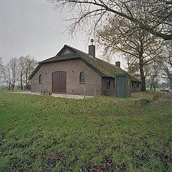
 Farm in Kamperveen | |
| Coordinates: 52°30′39″N 5°55′36″E / 52.5107°N 5.9266°E | |
| Country | Netherlands |
| Province | Overijssel |
| Municipality | Kampen |
| Area | |
| • Total | 21.93 km2 (8.47 sq mi) |
| Elevation | 2 m (7 ft) |
| Population (2021)[1] | |
| • Total | 915 |
| • Density | 42/km2 (110/sq mi) |
| Time zone | UTC+1 (CET) |
| • Summer (DST) | UTC+2 (CEST) |
| Postal code | 8278[1] |
| Dialing code | 038 |
Kamperveen is a village in the Dutch province of Overijssel. It is located in the municipality of Kampen, about 5 km south of the city.
Kamperveen was a separate municipality until 1937, when it became a part of IJsselmuiden.[3]
History[edit]
It was first mentioned in 1236 as "in Veno prope Campen", meaning "the bog of Kampen", and was originally a peat colony.[4]
Kamperveen is a confusing village, because it is a merger of the hamlets De Heuvels, De Roskam, De Zande, Hogeweg, Posthoorn and Zuideinde, therefore, it does not have a clear centre. There are directional signs to Kamperveen, however each hamlet is marked with its own name.[5]
Notable people[edit]
- Jan Terlouw (born 1931), politician and author[6]
References[edit]
- ^ a b c "Kerncijfers wijken en buurten 2021". Central Bureau of Statistics. Retrieved 18 March 2022.
- ^ "Postcodetool for 8278AA". Actueel Hoogtebestand Nederland (in Dutch). Het Waterschapshuis. Retrieved 18 March 2022.
- ^ Ad van der Meer and Onno Boonstra, Repertorium van Nederlandse gemeenten, KNAW, 2011.
- ^ "Kamperveen - (geografische naam)". Etymologiebank (in Dutch). Retrieved 18 March 2022.
- ^ "Kamperveen". Plaatsengids (in Dutch). Retrieved 18 March 2022.
- ^ "Dr. J.C. (Jan) Terlouw". Dutch Parliament (in Dutch). Retrieved 18 March 2022.


