
Gaoliying, Beijing
Gaoliying Town
高丽营镇 | |
|---|---|
.jpg) Building of government of Gaoliying Town 2024 | |
.png) Location of Gaoliying Town within Shunyi District | |
 Gaoliying Town  Gaoliying Town | |
| Coordinates: 40°09′28″N 116°29′36″E / 40.15778°N 116.49333°E | |
| Country | China |
| Municipality | Beijing |
| District | Shunyi |
| Village-level Divisions | 1 communities 25 villages |
| Area | |
| • Total | 61.77 km2 (23.85 sq mi) |
| Elevation | 39 m (128 ft) |
| Population (2020) | |
| • Total | 80,840 |
| • Density | 1,300/km2 (3,400/sq mi) |
| Time zone | UTC+8 (China Standard) |
| Postal code | 101303 |
| Area code | 010 |
Gaoliying Town (simplified Chinese: 高丽营镇; traditional Chinese: 高麗營鎮; pinyin: Gāolíyíng Zhèn) is a town just north of the Northern 6th Ring Road, in Shunyi District, Beijing.
The town is situated at the intersection of the Jingcheng Expressway, a six-lane expressway linking central Beijing via Huairou District and Miyun District to Chengde in Hebei province, and the 6th Ring Road. In the year 2020, its population was 80,840.[1]
The name Gaoliying (Chinese: 高丽营; lit. 'Goryeo Camp') refers to the large amount of immigrants from Goryeo that settled in this region during the Tang dynasty.[2]
History[edit]
| Time | Status | Belonged to |
|---|---|---|
| Qing dynasty | Gaoliying Town | Changping County |
| 1949–1950 | Shunyi County | |
| 1950–1956 | Changping County | |
| 1956–1958 | Gaoliying Township | Shunyi County |
| 1958–1975 | Zhangxizhuang People's Commune | |
| 1975–1983 | Gaoliying People's Commune
Zhangxizhuang People's Commune | |
| 1983–1989 | Gaoliying Township
Zhangxizhuang Township | |
| 1989–1998 | Gaoliying Town
Zhangxizhuang Town | |
| 1998–present | Gaoliying Town | Shunyi District |
Administrative divisions[edit]
As of 2021, Gaoliying Town consisted of 26 subdivisions, including 1 community and 25 villages:[3]
| Administrative Division Code | Subdisvision Names | Name Transliteration | Type |
|---|---|---|---|
| 110113101001 | 丽喜花园 | Lixi Huayuan | Community |
| 110113101201 | 一村 | Yicun | Village |
| 110113101202 | 二村 | Ercun | Village |
| 110113101203 | 三村 | Sancun | Village |
| 110113101204 | 四村 | Sicun | Village |
| 110113101205 | 五村 | Wucun | Village |
| 110113101206 | 六村 | Liucun | Village |
| 110113101207 | 七村 | Qicun | Village |
| 110113101208 | 八村 | Bacun | Village |
| 110113101209 | 南王路 | Nan Wanglu | Village |
| 110113101210 | 北王路 | Bei Wanglu | Village |
| 110113101211 | 西王路 | Xi Wanglu | Village |
| 110113101212 | 唐自头 | Tangzitou | Village |
| 110113101213 | 于庄 | Yuzhuang | Village |
| 110113101214 | 张喜庄 | Zhangxizhuang | Village |
| 110113101215 | 东马各庄 | Dong Magezhuang | Village |
| 110113101216 | 西马各庄 | Xi Magezhuang | Village |
| 110113101217 | 夏县营 | Xiaxianying | Village |
| 110113101218 | 河津营 | Hejinying | Village |
| 110113101219 | 南郎中 | Nan Langzhong | Village |
| 110113101220 | 后渠河 | Hou Quhe | Village |
| 110113101221 | 前渠河 | Qian Quhe | Village |
| 110113101222 | 闫家营 | Yanjiaying | Village |
| 110113101223 | 水坡 | Shuipo | Village |
| 110113101224 | 羊房 | Yangfang | Village |
| 110113101225 | 文化营 | Wenhuaying | Village |
Gallery[edit]
-
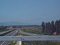 Gaoliying—also home to the northernmost extremity of the Jingcheng Expressway, 2004

See also[edit]
References[edit]
- ^ "北京市顺义区第七次全国人口普查公报发布". ie.bjd.com.cn (in Chinese (China)). Retrieved 2022-10-14.
- ^ a b 李立国; 李万钧; 吴世民, eds. (2013). 中华人民共和国政区大典, 北京市卷. Beijing: 中国社会出版社. ISBN 978-7-5087-4058-4. OCLC 910451741.
- ^ "2021年统计用区划代码和城乡划分代码". www.stats.gov.cn. Retrieved 2022-10-16.