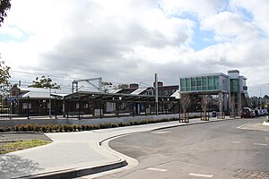
Revesby railway station
Revesby | |||||||||||||||||||||||
|---|---|---|---|---|---|---|---|---|---|---|---|---|---|---|---|---|---|---|---|---|---|---|---|
 Station from south in December 2012 | |||||||||||||||||||||||
| General information | |||||||||||||||||||||||
| Location | Blamey Street, Revesby | ||||||||||||||||||||||
| Coordinates | 33°57′09″S 151°00′53″E / 33.95243889°S 151.0148194°E | ||||||||||||||||||||||
| Elevation | 17 metres (56 ft) | ||||||||||||||||||||||
| Owned by | Transport Asset Holding Entity | ||||||||||||||||||||||
| Operated by | Sydney Trains | ||||||||||||||||||||||
| Line(s) | East Hills | ||||||||||||||||||||||
| Distance | 20.96 kilometres from Central | ||||||||||||||||||||||
| Platforms | 4 (2 island) | ||||||||||||||||||||||
| Tracks | 4 | ||||||||||||||||||||||
| Connections | Bus | ||||||||||||||||||||||
| Construction | |||||||||||||||||||||||
| Structure type | Ground | ||||||||||||||||||||||
| Accessible | Yes | ||||||||||||||||||||||
| Other information | |||||||||||||||||||||||
| Status |
Staffed: 6am-10pm
| ||||||||||||||||||||||
| Station code | RSY | ||||||||||||||||||||||
| Website | Transport for NSW | ||||||||||||||||||||||
| History | |||||||||||||||||||||||
| Opened | 21 December 1931 | ||||||||||||||||||||||
| Rebuilt | April 2013 | ||||||||||||||||||||||
| Electrified | Yes | ||||||||||||||||||||||
| Passengers | |||||||||||||||||||||||
| 2023[2] |
| ||||||||||||||||||||||
| Services | |||||||||||||||||||||||
| |||||||||||||||||||||||
Revesby railway station is located on the East Hills line, serving the Sydney suburb of Revesby. It is served by Sydney Trains T8 Airport & South line services.
History[edit]


Revesby station opened on 21 December 1931 when the line was extended from Kingsgrove to East Hills. In 1956 a crossing loop was opened.[3][4]
On 9 December 1985, the line from Revesby to East Hills was duplicated with a new track laid to the north of the existing one.[5] The line from Kingsgrove to Revesby was duplicated around the same time.[6]
The Rail Clearways Program saw the station's role change significantly, with plans to considerably boost capacity of the East Hills line by creating two centre turnbacks at the station to replace a side turnback at East Hills, and quadruplicating the line from Kingsgrove to Revesby.
In 2006, construction commenced on a second island platform and a replacement footbridge. Platform 3 opened in December 2008, as the main platform to the west. The existing Platform 2 became a centre turnback with only a few services initially using the facility.[7] In October 2009, a new timetable was introduced, and Revesby replaced East Hills as the major intermediate terminus.
In April 2013, as part of the quadruplication of the line from Kingsgrove to Revesby, Platform 4 opened.[8]
Platforms and services[edit]
| Platform | Line | Stopping pattern | Notes |
| 1 | services to Central & the City Circle via the Airport 6 weekday morning peak services to Central & the City Circle via Sydenham |
limited all stations services to City Circle via Airport | |
|---|---|---|---|
| 2 | terminating services to & from Central & the City Circle via the Airport and late night services from Macarthur and Leppington | [9] | |
| 3 | terminating services to & from Central & the City Circle via the Airport and late night Macarthur via Glenfield services | [9] | |
| 4 | services to Macarthur 8 weekday evening peak services to Campbelltown |
[9] |
Transport links[edit]
U-Go Mobility operates four bus routes via Revesby station, under contract to Transport for NSW:
- 923: Bankstown Central to Panania[10]
- 924: Bankstown Central to East Hills station[11]
- 926: Bankstown Central to Padstow station[12]
- 962: East Hills to Miranda
- S5: Padstow station to Milperra[13]
Revesby station is served by one NightRide route:
Trackplan[edit]

References[edit]
- ^ This figure is the number of entries and exits of a year combined averaged to a day.
- ^ "Train Station Monthly Usage". Open Data. Retrieved 26 January 2024.
- ^ Revesby Station NSWrail.net
- ^ Revesby Railway Station Group NSW Environment & Heritage
- ^ "Signalling & Safeworking" Railway Digest April 1986 page 119
- ^ "The East Hills to Glenfield Line" Railway Digest August 1986 pages 234-235
- ^ Airport & East Hills Line timetable changes CityRail December 2008
- ^ Kingsgrove to Revesby Quadruplication Project Profile Transport Infrastructure Development Corporation
- ^ a b c "T8: Airport & South line timetable". Transport for NSW.
- ^ "Transdev NSW route 923". Transport for NSW.
- ^ "Transdev NSW route 924". Transport for NSW.
- ^ "Transdev NSW route 926". Transport for NSW.
- ^ "Transdev NSW route S5". Transport for NSW.
- ^ "N40 Nightride". Transport for NSW.
External links[edit]
 Media related to Revesby railway station at Wikimedia Commons
- Photo gallery showing construction of the new turnback platforms
- Revesby station details Transport for New South Wales
