
Ōuda, Nara
Ōuda
大宇陀町 | |
|---|---|
Former municipality | |
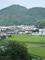
 The main street in Ōuda | |
 Ōuda Location in Japan | |
| Coordinates: 34°28′44.2″N 135°55′41.1″E / 34.478944°N 135.928083°E | |
| Country | Japan |
| Region | Kansai (Kinki) |
| Prefecture | Nara Prefecture |
| District | Uda |
| Merged | January 1, 2006 (now part of Uda) |
| Area | |
| • Total | 47.44 km2 (18.32 sq mi) |
| Population (2005) | |
| • Total | 8,647 |
| • Density | 180/km2 (470/sq mi) |
| Time zone | UTC+09:00 (JST) |
| Website | City of Uda |
| Symbols | |
| Bird | Bunting |
| Flower | Pinwheel |
| Tree | Oak |
Ōuda (大宇陀町, Ōuda-chō) was a town located in Uda District, Nara Prefecture, Japan.
As of 2005, the town had an estimated population of 8,647 and a density of 182.27 persons per km2. The total area was 47.44 km2.
On January 1, 2006, Ōuda, along with the towns of Haibara and Utano (all from Uda District), was merged to create the city of Uda.[1][2]
The town of Ōuda lies in a valley between two long mountain ranges in northeastern Nara, Japan. A three-mile long stretch of national routes 166 and 370 in the southern part of the town is where most of the businesses and homes are clustered. A large portion of flat land north on route 370 is less densely populated, covered mostly by rice fields. A large torii, or Japanese Gate, rises out of the rice paddies.
-
-
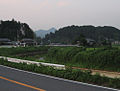 The outskirts of Ōuda


References[edit]
- ^ 住民基本台帳人口移動報告年報 [Annual Report on Population Movement in the Basic Resident Register] (in Japanese). 総務庁統計局. 2006. p. 138.
Ouda-cho, Utano-cho, Haibara-cho and Muro-mura were incorporated into a newly established Uda-shi as of January 1, 2006.
- ^ "宇陀市/宇陀市について". Uda City. Retrieved 2024-02-05.
| International | |
|---|---|
| National | |
| Academics | |
This Nara Prefecture location article is a stub. You can help Wikipedia by expanding it. |