
St. Paul Downtown Airport
St. Paul Downtown Airport Holman Field | |||||||||||||||||||
|---|---|---|---|---|---|---|---|---|---|---|---|---|---|---|---|---|---|---|---|
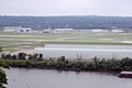
 Aerial photo of St. Paul Downtown Airport, with downtown St. Paul to the upper right, Mississippi River and MSP to the top left | |||||||||||||||||||
| Summary | |||||||||||||||||||
| Airport type | Public | ||||||||||||||||||
| Owner | Metropolitan Airports Commission | ||||||||||||||||||
| Serves | St. Paul, Minnesota | ||||||||||||||||||
| Location | St. Paul, Minnesota, USA | ||||||||||||||||||
| Elevation AMSL | 705 ft / 215 m | ||||||||||||||||||
| Coordinates | 44°56′04″N 093°03′36″W / 44.93444°N 93.06000°W | ||||||||||||||||||
| Map | |||||||||||||||||||
 STP Location of airport in Minnesota / United States  STP STP (the United States) | |||||||||||||||||||
| Runways | |||||||||||||||||||
| |||||||||||||||||||
| Statistics | |||||||||||||||||||
| |||||||||||||||||||
St. Paul Downtown Airport (IATA: STP, ICAO: KSTP, FAA LID: STP), also known as Holman Field, is an airport just across the Mississippi River from downtown Saint Paul, Minnesota. It is one of several reliever airports in the Twin Cities operated by the Metropolitan Airports Commission. The airport has three runways and serves aircraft operated by corporations in the local area, a flight training school and the Minnesota Army National Guard aviation unit, as well as transient general aviation aircraft.
The airport is home to an installation of the Minnesota Army National Guard. Two properties at the airport are listed on the National Register of Historic Places: the 1939 Holman Field Administration Building and the 1942 Riverside Hangar.[2]
History[edit]
Holman Field was named for Charles W. "Speed" Holman (1898–1931), who was a stunt pilot, barnstormer, wing walker, parachutist, airmail pilot, aviation record holder and airline pilot. Born in Bloomington, he was the first pilot hired by Northwest Airways in 1926. In 1928, Holman set a world record of 1,433 consecutive loops in an airplane in five hours over the St. Paul Airport. He died in an accident during an air show in Omaha in 1931 at the age of 32.[3]
During World War II, Northwest Airlines employed up to 5,000 people at the site, modifying new B-24 Liberator bombers, some of which received the highly classified H2X radar, which proved to be an invaluable tool in the European theater.[4]
The terminal was used as a backdrop for scenes in the 1972 film Slaughterhouse-Five.[citation needed]
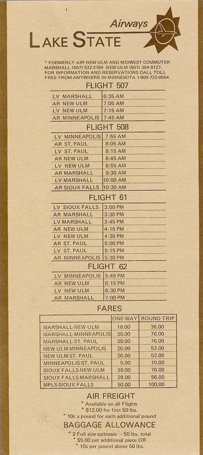
During the 1970s and early 1980s, commuter airline Lake State Airways offered scheduled airline service between the St. Paul Downtown Airport and Minneapolis–St. Paul International Airport in Minnesota. It cost $5USD for a one-way ticket between the two airports, and $10 round-trip.[5] Capitol Air flew MDW-STP with a Swearingen Metroliner for roughly a year starting in December 1993.
Facilities and aircraft[edit]
St. Paul Downtown Holman Field covers an area of 540 acres (220 ha) which contains three asphalt paved runways: 14/32 measuring 6,491 x 150 ft (1,978 x 46 m), 13/31 measuring 4,004 x 150 ft (1,220 x 46 m) and 9/27 measuring 3,642 x 100 ft (1,110 x 30 m).[1]St. Paul Downtown Airport was actually Minnesota's first international airport, with having a Customs and Immigration center on site.
For the 12-month period ending December 31, 2014, the airport had 66,475 aircraft operations, an average of 182 per day: 74% general aviation, 15% military and 11% air taxi. In January 2017, there were 68 aircraft based at this airport: 20 single-engine, 12 multi-engine, 18 jet, 7 helicopter and 11 military.[1]
Annual aircraft operations[edit]
Based on annual reports and data released by the Metropolitan Airports Commission, aircraft operations declined 65.3% in the decade 2011-2020.
| Year | Aircraft operations | Percent Change |
|---|---|---|
| 2011 | 87,229 [6] | N/A |
| 2012 | 79,238 [7] | |
| 2013 | 69,277 [8] | |
| 2014 | 64,539 [9] | |
| 2015 | 56,676 [10] | |
| 2016 | 54,548 [11] | |
| 2017 | 40,489 [12] | |
| 2018 | 40,116 [13] | |
| 2019 | 40,394 [14] | |
| 2020 | 30,188[15] | |
| 2021 | 39,196 [16] | |
| 2022 | 41,592 [17] |
Charter Airlines[edit]
| Airline | Services |
|---|---|
| NetJets | Charter |
| Executive Jet Management | Charter |
| Best Jets International | Charter/FBO |
| Delta Private Jets | Charter |
Cargo airlines[edit]
| Airline | Destinations |
|---|---|
| AirNet Express | Columbus-Rickenbacker, Milwaukee, Rochester (MN) |
Flood wall considerations[edit]
Recently local debate has ensued over plans to build a flood wall around the airport. In 1993, 1997, and 2001, the airport was flooded due to its proximity to the Mississippi River. Supporters do not want to deal with the future inconvenience of having to deal with the flood again, while critics say that the proposed wall would ruin views and make the airport "ugly".[18] A dike to protect the airport from the nearby river was considered since the National Guard stated that they may leave if the dike is not constructed in a timely manner.[citation needed]
In 2009, a removable flood wall was installed that is only erected when flooding is imminent, leaving the views of the river intact for the rest of the year. Steel plates are embedded in the concrete on the river side of the runways. The flood wall is composed of steel posts that anchor to the embedded plates and aluminum planks that are stacked between the posts to form a flood barrier. These are then removed and stored when the flood event has passed.
Gallery[edit]
-
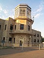 Holman Field administration building with historic control tower
 -
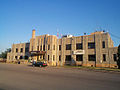 Holman Field administration building
 -
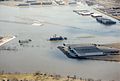 1990s flood
 -
 St. Paul Downtown Airport
 -
 View from a plane landing on runway 32 at Holman Field


See also[edit]
References[edit]
![]() This article incorporates public domain material from the Air Force Historical Research Agency
This article incorporates public domain material from the Air Force Historical Research Agency
- ^ a b c FAA Airport Form 5010 for STP PDF, effective Jan 5, 2017.
- ^ "Minnesota National Register Properties Database". Minnesota Historical Society. 2009. Retrieved 2018-01-01.
- ^ (nd) Ask A Historian Archived 2012-06-03 at the Wayback Machine. Ramsey County Historical Society. Retrieved 5/31/07.
- ^ Kenney, Dave (2004). Minnesota Goes to War - The Home front During World War II. Minnesota Historical Society Press. ISBN 978-0-87351-506-1. Retrieved 2008-01-30.
- ^ TimeTableImages.com
- ^ "Archived copy" (PDF). metroairports.org. Archived from the original (PDF) on 15 February 2021. Retrieved 22 May 2022.
{{cite web}}: CS1 maint: archived copy as title (link) - ^ https://metroairports.org/resources/annual-report-legislature-2012 [dead link]
- ^ https://web.archive.org/web/20210215033646/https://metroairports.org/sites/default/files/files/2014-annual-report-to-the-legislature.pdf
- ^ https://web.archive.org/web/*/https://metroairports.org/resources/2014-annual-report-legislature
- ^ https://web.archive.org/web/*/https://metroairports.org/resources/2015msplegislativereport
- ^ https://metroairports.org/resources/annual-report-2017 [dead link]
- ^ https://web.archive.org/web/*/https://metroairports.org/resources/annual-report-2017
- ^ https://web.archive.org/web/*/https://metroairports.org/resources/annual-report-2018
- ^ https://web.archive.org/web/*/https://metroairports.org/resources/2019-annual-report
- ^ "MAC Reliever Airports thrived in 2020 despite pandemic".
- ^ "St. Paul Downtown Airport (STP) 2021 Annual Report".
- ^ "Traffic at St. Paul's Holman Field airport increased nearly 5 percent in 2022". 8 February 2023.
- ^ Helms, Marisa (2006-04-05). "Airport flood project stirs the waters in St. Paul". Minnesota Public Radio. Retrieved 2008-01-30.
External links[edit]
- MSP Reliever Airports: St. Paul Downtown Airport
- "Minnesota Airport Directory: St. Paul Downtown Airport (Holman Field)" (PDF). Archived from the original (PDF) on 2006-09-24. (145 KB)
- FAA Airport Diagram (PDF), effective March 21, 2024
- Resources for this airport:
- FAA airport information for STP
- AirNav airport information for KSTP
- ASN accident history for STP
- FlightAware airport information and live flight tracker
- NOAA/NWS weather observations: current, past three days
- SkyVector aeronautical chart, Terminal Procedures
- Historic American Engineering Record (HAER) documentation, filed under Saint Paul, Ramsey County, MN:
- HAER No. MN-37, "Northwest Airways Hangar & Administration Building, 590 Bayfield Street", 31 photos, 20 data pages, 3 photo caption pages
- HAER No. MN-80, "Saint Paul Airport Municipal Hangar, 674 Bayfield Street", 10 photos, 5 measured drawings, 7 data pages, 1 photo caption page