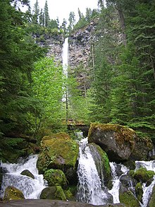
Watson Falls
| Watson Falls | |
|---|---|
 Watson Falls | |
 | |
| Location | North Umpqua River |
| Type | Plunge |
| Elevation | 3,214 ft (980 m) |
| Total height | 293 ft (89 m) |
Watson Falls is a 272-foot (83 m) waterfall on Watson Creek, a tributary of the Clearwater River, in Douglas County in the U.S. state of Oregon.[1] It is located at an elevation of 3,353 feet (1,022 m).[2]
See also[edit]
References[edit]
- ^ Bishop, Ellen Morris; Allen, John E. (2004). Hiking Oregon's geology. Seattle, Washington: Mountaineers Books. p. 159. ISBN 9780898868470. OCLC 53887464.
- ^ "Watson Falls". Geographic Names Information System. United States Geological Survey, United States Department of the Interior. November 28, 1980. Retrieved February 7, 2013.
External links[edit]
 Media related to Watson Falls at Wikimedia Commons
- Panoramic images of the falls from Don Bain's 360° Panoramas
43°14′29″N 122°23′24″W / 43.241511°N 122.390040°W
