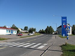
Pelkosenniemi
Pelkosenniemi
Pelkosnjargâ | |
|---|---|
Municipality | |
| Pelkosenniemen kunta Pelkosenniemi kommun | |
 | |
 Location of Pelkosenniemi in Finland | |
| Coordinates: 67°06.5′N 027°31′E / 67.1083°N 27.517°E | |
| Country | |
| Region | Lapland |
| Sub-region | Eastern Lapland |
| Charter | 1916 |
| Government | |
| • Municipal manager | Pertti Severinkangas |
| Area (2018-01-01)[1] | |
| • Total | 1,881.58 km2 (726.48 sq mi) |
| • Land | 1,836.38 km2 (709.03 sq mi) |
| • Water | 45.4 km2 (17.5 sq mi) |
| • Rank | 32nd largest in Finland |
| Population (2023-12-31)[2] | |
| • Total | 911 |
| • Rank | 299th largest in Finland |
| • Density | 0.5/km2 (1/sq mi) |
| Population by native language | |
| • Finnish | 98.3% (official) |
| • Swedish | 0.3% |
| • Others | 1.4% |
| Population by age | |
| • 0 to 14 | 9.5% |
| • 15 to 64 | 53.5% |
| • 65 or older | 37.1% |
| Time zone | UTC+02:00 (EET) |
| • Summer (DST) | UTC+03:00 (EEST) |
| Website | www.pelkosenniemi.fi |
Pelkosenniemi (Inari Sami: Pelkosnjargâ) is a municipality of Finland. It is located in the province of Lapland. The municipality has a population of 911 (31 December 2023),[2] which make it the smallest municipality in Lapland in terms of population. It covers an area of 1,881.58 square kilometres (726.48 sq mi) of which 45.4 km2 (17.5 sq mi) is water.[1] The population density is 0.5 inhabitants per square kilometre (1.3/sq mi). Neighbour municipalities are Kemijärvi, Rovaniemi, Salla, Savukoski and Sodankylä.
The municipality is unilingually Finnish and in 2000 was the last remaining municipality in Finland to have its entire population consist of native speakers of Finnish. As of 2010 there were two native speakers of other languages in Pelkosenniemi.
Pelkosenniemi hosts a popular mosquito swatting competition.[6]
History[edit]
The area was originally inhabited by Sámi people who spoke the Kemi Sámi language.
The first Finnish settler in the area was Paavali Pelkonen from Lumijoki, who came to the area, then called Kilpimaa, in the 1670s. The area was still property of the Sompio siida. Later it was a part of the Sodankylä parish, under which it acquired its first chapel in 1857. The community was called Alaperä at that time. Pelkosenniemi became a separate parish in 1916, as did Savukoski.[7]
Notable people[edit]
- Andy McCoy, formerly Antti Hulkko, lead guitarist of Hanoi Rocks, was born in Pelkosenniemi.
See also[edit]
References[edit]
- ^ a b "Area of Finnish Municipalities 1.1.2018" (PDF). National Land Survey of Finland. Retrieved 30 January 2018.
- ^ a b "Immigration record high in Finland in 2023". StatFin. Statistics Finland. Retrieved 25 January 2024.
- ^ "Demographic Structure by area as of 31 December 2022". Statistics Finland's PX-Web databases. Statistics Finland. Retrieved 6 September 2023.
- ^ "Population according to age (1-year) and sex by area and the regional division of each statistical reference year, 2003–2020". StatFin. Statistics Finland. Retrieved 2 May 2021.
- ^ a b "Luettelo kuntien ja seurakuntien tuloveroprosenteista vuonna 2023". Tax Administration of Finland. 14 November 2022. Retrieved 7 May 2023.
- ^ C.G. (11 October 2017). "Explaining the Finnish love of tango". The Economist.
- ^ "SuomalainenPaikannimikirja_e-kirja_kuvallinen.pdf" (PDF). kaino.kotus.fi (in Finnish). p. 325. Retrieved December 22, 2022.
External links[edit]
![]() Media related to Pelkosenniemi at Wikimedia Commons
Media related to Pelkosenniemi at Wikimedia Commons
![]() Pelkosenniemi travel guide from Wikivoyage
Pelkosenniemi travel guide from Wikivoyage
- Municipality of Pelkosenniemi – Official website


