
Dedemsvaart
Dedemsvaart
De Voart | |
|---|---|
 Dutch Reformed Church | |
 Dedemsvaart Location in province of Overijssel in the Netherlands  Dedemsvaart Dedemsvaart (Netherlands) | |
| Coordinates: 52°36′N 6°28′E / 52.600°N 6.467°E | |
| Country | Netherlands |
| Province | Overijssel |
| Municipality | Hardenberg |
| Established | 1811 |
| Area | |
| • Total | 34.99 km2 (13.51 sq mi) |
| Elevation | 7 m (23 ft) |
| Population (2021)[1] | |
| • Total | 12,840 |
| • Density | 370/km2 (950/sq mi) |
| Time zone | UTC+1 (CET) |
| • Summer (DST) | UTC+2 (CEST) |
| Postal code | 7701[1] |
| Dialing code | 0523 |
Dedemsvaart ("Dedem's Canal") (Dutch Low Saxon: De Voart) is a town in Overijssel, the Netherlands.
Overview[edit]
The town is located along an old canal, also called Dedemsvaart, which is the source of the village's name. The canal lost its commercial importance after World War II. The area around Dedemsvaart, until 2001 part of the municipality of Avereest, was an important centre for industry. Willem Jan van Dedem, after whom the canal and town were named,[3] made a plan to dig a canal; construction began on 9 July 1810. Around two years later, in 1811, the canal had already reached Balkbrug, and the town was established.[3]
In 1845 the project got into financial trouble and the baron had to forfeit the canal of Dedemsvaart, until then a private possession, to the province of Overijssel, who took further care of the canal.[4] Over the years the canal changed and eventually became unfit for commercial use.
The village of Dedemsvaart lies near the N377 between Balkbrug and Lutten. The municipality of Avereest was disbanded in 2001 and became part of the municipality of Hardenberg.[5] It's also the only settlement within the municipality where cannabis is semi-legally sold.[6]
Notable attractions[edit]
- Tuinen Mien Ruys, a complex of 25 gardens by noted Dutch landscape and garden architect Mien Ruys.
- Kalkovens, three big lime kilns, these were built in 1820.[3]
Notable people[edit]
- Henk Dorgelo (1894–1961), physicist and academic[7]
- Sanne Hans (born 1984), singer-songwriter[8]
- Daniel Koerhuis (born 1981), politician[9]
- Birgit Kos (born 1995), fashion model[10]
- Martin Koster (born 1950), author[11]
- Reinier Paping (1931–2021), speedskater, the winner of the 1963 Elfstedentocht better known as "the hell of '63"[12]
- Anna Charlotte Ruys (1898–1977), professor of bacteriology and epidemiology[13]
- Jannie Visscher (born 1961), politician[14]
- Jarno Westerman (born 2002), football player[15]
- Fernon Wibier (born 1971), tennis player[16]
Gallery[edit]
-
 Aerial photograph of Dedemsvaart
 -
 Roman Catholic church
 -
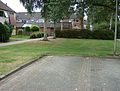 Little court
 -
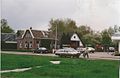 Street view


References[edit]
- ^ a b c "Kerncijfers wijken en buurten 2021". Central Bureau of Statistics. Retrieved 14 March 2022.
- ^ "Postcodetool for 7701AA". Actueel Hoogtebestand Nederland (in Dutch). Het Waterschapshuis. Retrieved 14 March 2022.
- ^ a b c Ronald Stenvert & Jan ten Hove (1998). "Dedemsvaart" (in Dutch). Zwolle: Waanders. p. 82. ISBN 90 400 9200 1. Retrieved 14 March 2022.
- ^ "Willem Jan baron van Dedem (1776-1851)". Wie is wie in Overijssel (in Dutch). Retrieved 14 March 2022.
- ^ "Dedemsvaart". Plaatsengids (in Dutch). Retrieved 14 March 2022.
- ^ "Legalisering softdrugketen". De Stentor (in Dutch). 2008-11-22. Retrieved 2023-10-28.
- ^ "Dorgelo H.B." University of Twente Encyclopedia (in Dutch). Retrieved 14 March 2022.
- ^ "Miss Montreal". Avtrotros (in Dutch). Retrieved 14 March 2022.
- ^ "Drs. D.A.N. (Daniel) Koerhuis". Dutch Parliament. Retrieved 14 March 2022.
- ^ "17 Breakout Models From the Fall 2017 Shows". Fashionista. Retrieved 14 March 2022.
- ^ "Auteurs uit Dedemsvaart (De Vaort)". De Taal van Overijssel (in Dutch). Retrieved 14 March 2022.
- ^ "Reinier Paping, winnaar Elfstedentocht 1963 overleden". Elfstedensite (in Dutch). Retrieved 14 March 2022.
- ^ Mineke Bosch, Ruys. "Ruys, Anna Charlotte (1898-1977)". Digitaal Vrouwenlexicon van Nederland (in Dutch). Retrieved 14 March 2022.
- ^ "Eindhovense Jannie Visscher naar Brussel?". Socialist Party Helmond (in Dutch). Retrieved 14 March 2022.
- ^ "J. Westerman". Soccerway. Retrieved 14 March 2022.
- ^ "Wibier probeert achterbuurt van Monte Carlo te ontgroeien". Trouw (in Dutch). Retrieved 14 March 2022.
| Authority control databases: Geographic |
|---|