
Mariveles
Mariveles | |
|---|---|
| Municipality of Mariveles | |
 | |
 Flag  Seal | |
 Map of Bataan with Mariveles highlighted | |
OpenStreetMap  | |
.svg) Mariveles Location within the Philippines | |
| Coordinates: 14°26′N 120°29′E / 14.43°N 120.48°E | |
| Country | Philippines |
| Region | Central Luzon |
| Province | Bataan |
| District | 3rd district |
| Founded | 1754 |
| Barangays | 18 (see Barangays) |
| Government | |
| • Type | Sangguniang Bayan |
| • Mayor | Ace Jello Concepcion |
| • Vice Mayor | Angelito S. Rubia |
| • Representative | Maria Angela Garcia |
| • Municipal Council | Members |
| • Electorate | 89,085 voters (2022) |
| Area | |
| • Total | 153.90 km2 (59.42 sq mi) |
| Elevation | 96 m (315 ft) |
| Highest elevation | 561 m (1,841 ft) |
| Lowest elevation | 0 m (0 ft) |
| Population (2020 census)[3] | |
| • Total | 149,879 |
| • Density | 970/km2 (2,500/sq mi) |
| • Households | 39,410 |
| Economy | |
| • Income class | 1st municipal income class |
| • Poverty incidence | 4.90 |
| • Revenue | ₱ 807.9 million (2020) |
| • Assets | ₱ 2,379 million (2020) |
| • Expenditure | ₱ 782.2 million (2020) |
| • Liabilities | ₱ 2,056 million (2020) |
| Service provider | |
| • Electricity | Peninsula Electric Cooperative (PENELCO) |
| Time zone | UTC+8 (PST) |
| ZIP code | 2105, 2106 (Freeport Area of Bataan), 2109 (Cabcaben) |
| PSGC | |
| IDD : area code | +63 (0)47 |
| Native languages | Mariveleño Tagalog |
| Website | marivelesbataan |
Mariveles, officially the Municipality of Mariveles (Tagalog: Bayan ng Mariveles), is a 1st class municipality in the province of Bataan, Philippines. According to the 2020 census, it has a population of 149,879 people.[3]
History[edit]
Founded as a pueblo by a Franciscan Friar in 1578, Mariveles, the "Village of Camaya" was part of the Corregimiento of Mariveles, including Bagac and Morong, Corregidor and Maragondon, Cavite. The name Mariveles comes from "Maria Velez", a Mexican nun who eloped with a monk back in 1600s. With its natural cove, the port was used by ships from China and Spain to resupply.[5]
The Superior Decree of July 1754 declared Mariveles' independence from Pampanga.
In the 19th century, the Americans established the first quarantine station in the old Spanish Leprosarium Hospital (now, the Mariveles Mental Wellness and General Hospital).
Mariveles Bay was the site of Mariveles Naval Section Base, completed for the United States Asiatic Fleet on 22 July 1941, and was surrendered to the Imperial Japanese Army on 9 April 1942. The Mariveles Airfield, a 3,800-foot (1,200 m) dirt runway at the Section Base, was the starting point of the Bataan Death March.[6]
Today the Freeport Area of Bataan (FAB), has made the port of trading zone, and industry to the municipality. Agriculture is also a large part of the port export.[5]
Geography[edit]
Mariveles is located around the Mariveles Bay, a large cove at the southern tip of the Bataan Peninsula. It adjacent to Manila Bay to the east, and the South China Sea to the west.
Mariveles is 40 kilometres (25 mi) from Balanga and 164 kilometres (102 mi) from Manila via the North Luzon Expressway (NLEX), Jose Abad Santos Avenue, and Roman Highway. It borders Bagac to the west and northwest, Limay to the north and northeast, and Manila Bay to the east.
According to the Philippine Statistics Authority, the municipality has a land area of 153.90 square kilometres (59.42 sq mi) [7] constituting 11.21% of the 1,372.98-square-kilometre- (530.11 sq mi) total area of Bataan. Of this, about 69% consist of the pastureland, 19% of forestland, 6% agricultural lands and the remaining 6% for residential and industrial use.
Climate[edit]
| Climate data for Mariveles, Bataan | |||||||||||||
|---|---|---|---|---|---|---|---|---|---|---|---|---|---|
| Month | Jan | Feb | Mar | Apr | May | Jun | Jul | Aug | Sep | Oct | Nov | Dec | Year |
| Mean daily maximum °C (°F) | 31 (88) |
32 (90) |
34 (93) |
35 (95) |
33 (91) |
31 (88) |
29 (84) |
29 (84) |
29 (84) |
29 (84) |
30 (86) |
31 (88) |
31 (88) |
| Mean daily minimum °C (°F) | 19 (66) |
19 (66) |
20 (68) |
23 (73) |
25 (77) |
25 (77) |
24 (75) |
25 (77) |
25 (77) |
24 (75) |
23 (73) |
20 (68) |
23 (73) |
| Average precipitation mm (inches) | 7 (0.3) |
8 (0.3) |
14 (0.6) |
26 (1.0) |
127 (5.0) |
210 (8.3) |
263 (10.4) |
272 (10.7) |
218 (8.6) |
114 (4.5) |
46 (1.8) |
21 (0.8) |
1,326 (52.3) |
| Average rainy days | 4.0 | 4.0 | 6.9 | 11.2 | 21.0 | 24.5 | 27.4 | 26.9 | 25.9 | 21.9 | 13.4 | 6.3 | 193.4 |
| Source: Meteoblue (modeled/calculated data, not measured locally)[8] | |||||||||||||
Barangays[edit]
Mariveles is politically subdivided into 18 barangays, with two are located within the jurisdiction of Freeport Area of Bataan (FAB).[9] Each barangay consists of puroks and some have sitios.
| PSGC | Barangay | Population | ±% p.a. | |||
|---|---|---|---|---|---|---|
| 2020[3] | 2010[10] | |||||
| 030807001 | Alas‑asin | 10.0% | 15,047 | 11,606 | 2.63% | |
| 030807002 | Alion | 2.2% | 3,264 | 3,015 | 0.80% | |
| 030807013 | Balon‑Anito | 8.2% | 12,286 | 10,255 | 1.82% | |
| 030807006 | Baseco Country (Nassco) | 3.1% | 4,581 | 3,440 | 2.91% | |
| 030807003 | Batangas II | 4.0% | 5,951 | 5,122 | 1.51% | |
| 030807014 | Biaan | 1.2% | 1,837 | 1,571 | 1.58% | |
| 030807004 | Cabcaben | 4.3% | 6,427 | 6,269 | 0.25% | |
| 030807015 | Camaya | 9.9% | 14,869 | 12,077 | 2.10% | |
| 030807016 | Ipag | 6.7% | 10,010 | 9,430 | 0.60% | |
| 030807005 | Lucanin | 3.4% | 5,169 | 3,570 | 3.77% | |
| 030807017 | Malaya | 3.3% | 4,910 | 5,211 | −0.59% | |
| 030807018 | Maligaya | 2.9% | 4,407 | 4,416 | −0.02% | |
| 030807019 | Mt. View | 7.0% | 10,461 | 8,843 | 1.69% | |
| 030807008 | Poblacion | 5.3% | 7,938 | 8,074 | −0.17% | |
| 030807009 | San Carlos | 1.0% | 1,517 | 1,592 | −0.48% | |
| 030807010 | San Isidro | 3.8% | 5,761 | 5,816 | −0.09% | |
| 030807011 | Sisiman | 4.2% | 6,221 | 5,837 | 0.64% | |
| 030807020 | Townsite | 4.6% | 6,880 | 6,563 | 0.47% | |
| Total | 149,879 | 112,707 | 2.89% | |||
Demographics[edit]
|
| |||||||||||||||||||||||||||||||||||||||||||||||||||
| Source: Philippine Statistics Authority[11][10][12][13] | ||||||||||||||||||||||||||||||||||||||||||||||||||||
In the 2020 census, Mariveles had a population of 149,879.[3] The population density was 970 inhabitants per square kilometre (2,500/sq mi).
Mariveles is home to an Aeta community speaking a Sambalic language called Mariveleño.
Economy[edit]
Graphs are unavailable due to technical issues. There is more info on Phabricator and on MediaWiki.org. |
.jpg)
The Freeport Area of Bataan[21] (formerly known as Bataan Export Processing Zone from November 20, 1972, to June 30, 2010) is a 1,691 hectares (4,180 acres) industrial complex in Mariveles town that enjoys business advantages, including tax incentives, natural endowments, and leadership under Authority of the Freeport Area of Bataan (AFAB) Chairman Mohammed Hussein Pangandaman.[22] It is the only freeport in the country with a 10.9 million cubic meter-capacity dam that delivers 14 million gallons of water every day. It is complemented by water treatment and sewerage treatment plants which employ a sustainable waste water solution.
Government[edit]
Local government[edit]

Pursuant to the Local government in the Philippines",[23][24] the political seat of the municipal government is located at the Municipal Hall. In the History of the Philippines (1521–1898), the Gobernadorcillo is the Chief Executive who held office in the Presidencia. During the American rule (1898–1946) (History of the Philippines (1898-1946)), the elected Mayor and local officials, including the appointed ones held office at the Municipal Hall. The legislative and executive departments perform their functions in the Sangguniang Bayan (Session Hall) and Municipal Trial Court, respectively, and are located in the second floor of the Town Hall and in the adjacent building.
The Municipal Mayor as of the 2022 national and local elections, serving his first term in office, is Ace Jello "AJ" C. Concepcion.
Elected officials[edit]
Members of the Mariveles Municipal Council (2022-2025):[25]
- Municipal Mayor: Ace Jello Concepcion
- Municipal Vice Mayor: Angelito S. Rubia
- Municipal Councilors:
- Ronald R. Arcenal
- Susan M. Murillo
- Jester Ivan O. Ricafrente
- Jose M. Carandang
- Danilo T. Banal
- Omar B. Cornejo
- Vonnel A. Isip
- Jeff B. Peñaloza
- Municipal ABC President: Venancio L. Villapando Jr.
District Representative (3rd Legislative District, Bataan): Maria Angela Garcia
Tourism[edit]

Mariveles' attractions, events and historical landmarks include:
- Mariveles Five Fingers: A series of coves that looks like five human fingers when viewed from the air.
- Mount Mariveles
- Km 0 marker of the Bataan Death March
- Lazareto de Mariveles: A Quarantine station established by the Spanish government in the 1850s to check and sanitize cargoes and passengers entering Manila. The Americans, upon their conquest of the Philippines, used the same system in their ports.[26][27] The ruins of the old facility can be found inside the Mariveles Mental Hospital compound in downtown Mariveles.
- Mariveles Church
Infrastructure[edit]
Transportation[edit]
Mariveles can be reached through jet ferry plying the Mariveles to Manila route that has an approximate travel time of 40 minutes.
Expressway[edit]
The Bataan Provincial Expressway, also called Roman Super-Highway, is a limited-access toll expressway that connects Bataan to the provinces of the Central Luzon region in the Philippines. Mariveles is off Exit 55.
Energy sources[edit]

Utilities:
- Mariveles geothermal area in Bataan: a geothermal area situated along the West Luzon Volcanic Arc.[28]
- GN Power Mariveles Coal Plant (GMCP), Alas-asin: 600-megawatt coal-fired power plant ($155 million was purchased by Conglomerate Ayala Corp. in December 2012).[29]
- National Grid Corporation of the Philippines (NGCP) Mariveles Substation which hosts three 500 kV transmission lines which are Mariveles–Balsik, MPGC Mariveles–NGCP Mariveles, and GNPower Dinginin–NGCP Mariveles lines. The first is operated and maintained by NGCP, while the last two are by power generation companies (Mariveles Power Generation Corporation (MPGC) and GN Power Dinginin Ltd. Co. (GNPD) while having ownership on both respective lines).
Education[edit]

Tertiary educational institutions include:
- Polytechnic University of the Philippines Bataan (PUP), a state university that offers baccalaureate (college) degrees where students are scholars of the government (after passing an entrance exam). Opened in 1976, the campus is located at Barangay Malaya, Freeport Area of Bataan (FAB).
- Maritime Academy of Asia and the Pacific (MAAP) located at Kamaya Point, Barangay Alas-asin, offering courses in the maritime industry. Students are accepted after passing stringent academic and physical examinations.
- TESDA Mariveles Bataan Branch, located at Barangay Camaya and near the Public Market, Mariveles Municipal Hall, and Freeport Area of Bataan, offering technical and vocational courses.
- Softnet Information Technology Center (SITC) located at second floor SFB #8, FAB, offering associate degrees in computer studies.
- Llamas Memorial Institute Inc.
Gallery[edit]
-
 Bay Walk, People's Park
 -
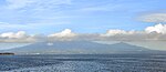 Remote view of Mariveles
 -
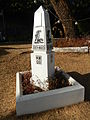 Zero Kilometer Death March Marker
 -
 Bataan Peninsula on 24 January 1945, with Mariveles Seaplane base, port and Airfield. Japan is bombing the runway. Mariveles surrendered on April 10, 1942 the start of Bataan Death March. Mariveles was retaken in February 1945
 -
 Mariveles District Hospital


.jpg)
See also[edit]
References[edit]
- ^ Municipality of Mariveles | (DILG)
- ^ "2015 Census of Population, Report No. 3 – Population, Land Area, and Population Density" (PDF). Philippine Statistics Authority. Quezon City, Philippines. August 2016. ISSN 0117-1453. Archived (PDF) from the original on May 25, 2021. Retrieved July 16, 2021.
- ^ a b c d Census of Population (2020). "Region III (Central Luzon)". Total Population by Province, City, Municipality and Barangay. Philippine Statistics Authority. Retrieved 8 July 2021.
- ^ "PSA Releases the 2018 Municipal and City Level Poverty Estimates". Philippine Statistics Authority. 15 December 2021. Retrieved 22 January 2022.
- ^ a b "Mariveles". bataan.gov.ph. Provincial Government of Bataan. Retrieved 30 August 2022.
- ^ "Mariveles Airfield, Bataan Province, Philippines". pacificwrecks.com. Pacific Wrecks Inc. Retrieved 30 August 2022.
- ^ "Province: Bataan". PSGC Interactive. Quezon City, Philippines: Philippine Statistics Authority. Retrieved 12 November 2016.
- ^ "Mariveles: Average Temperatures and Rainfall". Meteoblue. Retrieved 26 April 2020.
- ^ "Municipal: Mariveles". PSGC Interactive. Quezon City, Philippines: Philippine Statistics Authority. Retrieved 8 January 2016.
- ^ a b Census of Population and Housing (2010). "Region III (Central Luzon)" (PDF). Total Population by Province, City, Municipality and Barangay. National Statistics Office. Retrieved 29 June 2016.
- ^ Census of Population (2015). "Region III (Central Luzon)". Total Population by Province, City, Municipality and Barangay. Philippine Statistics Authority. Retrieved 20 June 2016.
- ^ Censuses of Population (1903–2007). "Region III (Central Luzon)". Table 1. Population Enumerated in Various Censuses by Province/Highly Urbanized City: 1903 to 2007. National Statistics Office.
{{cite encyclopedia}}: CS1 maint: numeric names: authors list (link) - ^ "Province of Bataan". Municipality Population Data. Local Water Utilities Administration Research Division. Retrieved 17 December 2016.
- ^ "Poverty incidence (PI):". Philippine Statistics Authority. Retrieved December 28, 2020.
- ^ "Estimation of Local Poverty in the Philippines" (PDF). Philippine Statistics Authority. 29 November 2005.
- ^ "2003 City and Municipal Level Poverty Estimates" (PDF). Philippine Statistics Authority. 23 March 2009.
- ^ "City and Municipal Level Poverty Estimates; 2006 and 2009" (PDF). Philippine Statistics Authority. 3 August 2012.
- ^ "2012 Municipal and City Level Poverty Estimates" (PDF). Philippine Statistics Authority. 31 May 2016.
- ^ "Municipal and City Level Small Area Poverty Estimates; 2009, 2012 and 2015". Philippine Statistics Authority. 10 July 2019.
- ^ "PSA Releases the 2018 Municipal and City Level Poverty Estimates". Philippine Statistics Authority. 15 December 2021. Retrieved 22 January 2022.
- ^ "PIA | Philippine Information Agency | Bataan officials: Bring on the jobs, we are ready". Philippine Information Agency. Archived from the original on 2013-04-16. Retrieved 2013-02-03.
- ^ "PIA | Philippine Information Agency | Bataan freeport czar bares 'superior facilities' to Turkish tycoons". Philippine Information Agency. Archived from the original on 2013-04-16. Retrieved 2013-02-03.
- ^ "Philippines : Gov.Ph : About the Philippines". www.gov.ph. Archived from the original on 2009-01-22. Retrieved 2009-03-28.
- ^ "The Local Government Code Of The Philippines - Chan Robles Virtual Law Library". Chanrobles.com. Retrieved 2016-11-21.
- ^ "Mariveles - Municipal Officials". Marivelesbataan.gov.ph. 2023-11-01. Retrieved 2023-11-01.
- ^ "100 SIgnificant Events in Philippine History". The Manila Times. September 18, 2006. Retrieved 21 December 2014.
- ^ Shellum, Brian (February 1, 2010). Black Officer in a Buffalo Soldier Regiment: The Military Career of Charles Young (1st ed.). Bison Books. p. 134. ISBN 978-0803213852.
- ^ "DOE set to award 4 renewable energy contracts". Philippine Daily Inquirer. 2013-01-06. Retrieved 2016-11-21.
- ^ Dela, Zinnia B. (2012-12-18). "Ayala buys into Mariveles power plant". The Philippine Star. Retrieved 2016-11-21.
External links[edit]
Places adjacent to Mariveles | ||||||||||||||||
|---|---|---|---|---|---|---|---|---|---|---|---|---|---|---|---|---|
| ||||||||||||||||
| Municipalities | |
|---|---|
| Component city | |
