
Ljusdal Municipality
Ljusdal Municipality
Ljusdals kommun | |
|---|---|
 | |
 Coat of arms | |
 | |
| Coordinates: 61°50′N 16°05′E / 61.833°N 16.083°E | |
| Country | Sweden |
| County | Gävleborg County |
| Seat | Ljusdal |
| Area | |
| • Total | 5,609.84 km2 (2,165.97 sq mi) |
| • Land | 5,256.7 km2 (2,029.6 sq mi) |
| • Water | 353.14 km2 (136.35 sq mi) |
| Area as of 1 January 2014. | |
| Population (31 December 2023)[2] | |
| • Total | 18,538 |
| • Density | 3.3/km2 (8.6/sq mi) |
| Time zone | UTC+1 (CET) |
| • Summer (DST) | UTC+7 (CEST) |
| ISO 3166 code | SE |
| Province | Hälsingland |
| Municipal code | 2161 |
| Website | www |
Ljusdal Municipality (Ljusdals kommun) is one of Sweden's 290 municipalities within Gävleborg County. Its seat is Ljusdal.
The municipality was formed in 1971 by the amalgamation of the market town (köping) of Ljusdal (instituted in 1914) with the rural municipalities Järvsö, Färila, Los and Ramsjö.
Ljusdal is known for its successful bandy team and for the annual Bandy World Cup that used to be held in the town.
Geography[edit]
Geographically the town is located on the shores of the river Ljusnan, along the shores of which Sweden's northern main line railway (Norra Stambanan) stretches. The municipality calls itself "Sweden's nearest Norrland", with Norrland being historically how Sweden's north was referred to. Geographically, the municipality is located at the centre of Sweden.
In this large municipality (Sweden's 25th largest) there are several nature activities one can enjoy. Along Ljusnan there are a total of 40 kilometers of water ways, with possibilities for sailing, rafting, fishing or taking a tour with the tour boats. Hamra National Park is also located partly within the western parts of the municipality.
Localities[edit]

Figures as of 2004, from Statistics Sweden:
- Ljusdal 7,559
- Järvsö 1,907
- Färila 1,542
- Tallåsen 807
- Los 469
- Hybo 351
- Ramsjö 306
- Hennan 227
- Korskrogen 202
- Kårböle 134
Demographics[edit]
This is a demographic table based on Ljusdal Municipality's electoral districts in the 2022 Swedish general election sourced from SVT's election platform, in turn taken from SCB official statistics.[3]
In total there were 14,791 Swedish citizens of voting age resident in the municipality.[3] 48.1% voted for the left coalition and 50.8% for the right coalition. Indicators are in percentage points except population totals and income.
| Location | Residents | Citizen adults |
Left vote | Right vote | Employed | Swedish parents |
Foreign heritage |
Income SEK |
Degree |
|---|---|---|---|---|---|---|---|---|---|
| % | % | ||||||||
| Färila | 2,102 | 1,700 | 43.8 | 55.1 | 82 | 93 | 7 | 22,627 | 21 |
| Järvsö N | 1,307 | 1,078 | 50.6 | 48.3 | 84 | 93 | 7 | 23,964 | 35 |
| Järvsö V | 1,917 | 1,551 | 52.3 | 46.7 | 82 | 93 | 7 | 22,027 | 32 |
| Järvsö Ö | 1,109 | 875 | 56.1 | 43.0 | 88 | 95 | 5 | 24,800 | 39 |
| Korskrogen-Kårböle | 1,154 | 906 | 46.5 | 52.2 | 81 | 91 | 9 | 22,912 | 25 |
| Ljusdal C | 1,448 | 1,217 | 51.6 | 47.1 | 75 | 80 | 20 | 20,350 | 26 |
| Ljusdal N | 1,712 | 1,411 | 47.2 | 51.7 | 83 | 88 | 12 | 24,288 | 30 |
| Ljusdal S | 1,503 | 1,173 | 46.5 | 52.3 | 78 | 91 | 9 | 24,063 | 21 |
| Ljusdal V | 1,978 | 1,596 | 45.7 | 53.4 | 85 | 92 | 8 | 25,913 | 31 |
| Ljusdal Ö | 1,816 | 1,087 | 54.0 | 45.0 | 60 | 58 | 42 | 17,601 | 21 |
| Los-Hamra | 655 | 530 | 47.3 | 50.5 | 71 | 88 | 12 | 18,611 | 26 |
| Ramsjö-Hennan | 545 | 487 | 42.2 | 55.7 | 74 | 90 | 10 | 21,018 | 19 |
| Tallåsen | 1,541 | 1,180 | 41.4 | 58.2 | 86 | 96 | 4 | 25,234 | 21 |
| Source: SVT[3] | |||||||||
History[edit]
The area had a large immigration from Finland in the 17th and 18th century in the western part of the municipality known as Orsa Finnmark (in Dalarna). Still there are many names which trace this Finnish influence. In Ljusdal a museum dedicated to the regions history is now located in a former dairy, and in Järvsö there is the Stenegård cultural centre.
The population was boosted when the mainline railway was constructed here in the late 19th century.
Tourism[edit]
Tourism in the municipality is focussed on Järvsö. Popular tourist activities in Järvsö include skiing on Järvsöbacken and visiting Järvzoo.
Nature[edit]
Gröntjärn Nature Reserve is located in Ljusdal Municipality around 20 kilometers north of Ljusdal. Here several Kettle holes formed during glacial retreat, where ice blocks melted under sediments. The pool is not fed by streams but by groundwater and can see large variations in the lake level. The ground water source also gives the lake it is characteristic turquoise-green colouring.[4]
Sister cities[edit]
- Denmark : Glamsbjerg
- Norway: Tynset
- Finland: Ikaalinen
- Estonia: Vinni
- Germany: Schlieben
Gallery[edit]
-
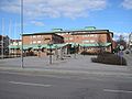 Ljusdal Municipal Building on Rio square
 -
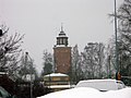 The Water tower
 -
 The church of Ljusdal
 -
 Ljusdalsbygdens museum
 -
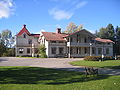 Historic Borrgården


See also[edit]
References[edit]
- ^ "Statistiska centralbyrån, Kommunarealer den 1 januari 2014" (in Swedish). Statistics Sweden. 2014-01-01. Archived from the original (Microsoft Excel) on 2016-09-27. Retrieved 2014-04-18.
- ^ "Folkmängd och befolkningsförändringar - Kvartal 4, 2023" (in Swedish). Statistics Sweden. February 22, 2024. Retrieved February 22, 2024.
- ^ a b c "Valresultat 2022 för Ljusdal i riksdagsvalet" (in Swedish). SVT. 11 September 2022. Retrieved 21 December 2023.
- ^ "Gröntjärn". Länsstyrelsen Gävleborg. Retrieved 10 May 2014.
External links[edit]
- Ljusdal – official website
- Sweden's Nearest Norrland – tourism website in Swedish/English/German
- Energy Flow Survey of Ljusdal's Municipality – pdf
- Energy flow survey of Ljusdals municipality (Abstract)
Places adjacent to Ljusdal Municipality | ||||||||||||||||
|---|---|---|---|---|---|---|---|---|---|---|---|---|---|---|---|---|
| ||||||||||||||||
Municipalities and seats of Gävleborg County | ||
|---|---|---|
| Municipalities | ||
| Municipal seats | ||
| International | |
|---|---|
| National | |
| Geographic | |