
Sand River (Ontario)
| Sand River Rivière Sand (in French) | |
|---|---|
 Looking downstream to Ontario Highway 17 bridge and the river mouth | |
 Location of the mouth of the Sand River in Ontario. | |
| Etymology | named after the sand bar formed across its mouth. |
| Native name | Pinguisibi (Ojibwe) |
| Location | |
| Country | Canada |
| Province | Ontario |
| Region | Northeastern Ontario |
| District | Algoma |
| Part | Algoma, Unorganized, North |
| Physical characteristics | |
| Source | Sand Lake |
| • location | Stoney Township |
| • coordinates | 47°41′56″N 84°33′10″W / 47.69889°N 84.55278°W |
| • elevation | 375 m (1,230 ft) |
| Mouth | Lake Superior |
• location | Goodwillie Township |
• coordinates | 47°25′58″N 84°43′50″W / 47.43278°N 84.73056°W |
• elevation | 180 m (590 ft) |
| Basin features | |
| River system | Great Lakes Basin |
| Tributaries | |
| • left | Kwagama Creek |
The Sand River (French: Rivière Sand[1]) is a river in the Unorganized North Part of Algoma District in Northeastern Ontario, Canada.[2][3] It is in the Great Lakes Basin, is a tributary of Lake Superior, and its entire course lies within Lake Superior Provincial Park.[4]
The river is named after the sand bar formed across its mouth. The Ojibway name for the river is Pinguisibi, where pingui means fine white sand and sibi means river.[5]
Course[edit]
The Sand River begins at Sand Lake, in geographic Stoney Township,[6] on which is located the railway point of Sand Lake on the Algoma Central Railway.[3] It leaves the lake South over Sand Lake Dam about 4.4 kilometres (2.7 mi) west of the community of Millwood.[6] It travels South into geographic Barnes Township,[7] geographic Barager Township,[8] and geographic Broome Township,[9] the latter in which it heads over Calwin Falls. The river continues south into geographic Goodwillie Township,[10] flows over Lady Evelyn Falls, and takes in the left tributary Kwagama Creek. It then heads southwest, descends a series of low cascades, passes under Ontario Highway 17 and reaches its mouth at Lake Superior.
Recreation[edit]
The entire river is a designated canoe route. There is a picnic area at the mouth of the river next to Highway 17 where many travelers stop to enjoy a view of the cascading falls,[4] and the Pinguisibi hiking trail follows the right bank from the river mouth.[4][11]
Tributaries[edit]
- Kwagama Creek
- Sand Lake
- Sand Creek
-
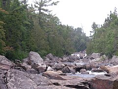 Sand River Looking Upstream near Lake Superior
 -
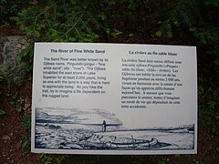 Historical Sign on the Bank of the River
 -
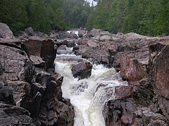 Sand River water cascades looking upstream


See also[edit]
References[edit]
- ^ "Sand Lake - Sandbar Lake Provincial Park". Ontario GeoNames Index. 2011-07-22. Retrieved 2011-11-04.
- ^ "Sand River". Geographical Names Data Base. Natural Resources Canada. Retrieved 2011-11-04.
- ^ a b "Sand River". Atlas of Canada. Natural Resources Canada. Retrieved 2011-11-04. Shows river course.
- ^ a b c "Park map". Lake Superior Provincial Park. MHS Webteam & Larrett Designs. Retrieved 2011-11-04.
- ^ Picture of Sign on the River Bank. Accessed 2011-11-04.
- ^ a b "Stoney" (PDF). Geology Ontario - Historic Claim Maps. Ontario Ministry of Northern Development, Mines and Forestry. Retrieved 2011-11-05.
- ^ "Barnes" (PDF). Geology Ontario - Historic Claim Maps. Ontario Ministry of Northern Development, Mines and Forestry. Retrieved 2011-11-05.
- ^ "Barager" (PDF). Geology Ontario - Historic Claim Maps. Ontario Ministry of Northern Development, Mines and Forestry. Archived from the original (PDF) on 2012-04-26. Retrieved 2011-11-05.
- ^ "Broome" (PDF). Geology Ontario - Historic Claim Maps. Ontario Ministry of Northern Development, Mines and Forestry. Archived from the original (PDF) on 2012-04-26. Retrieved 2011-11-05.
- ^ "Goodwillie" (PDF). Geology Ontario - Historic Claim Maps. Ontario Ministry of Northern Development, Mines and Forestry. Retrieved 2011-11-05.
- ^ "Pinguisibi (Sand River) Trail". Lake Superior Provincial Park. MHS Webteam & Larrett Designs. Retrieved 2011-11-04.