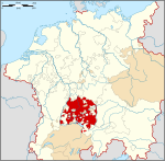
Königsegg-Rothenfels
Barony (County) of Königsegg-Rothenfels Freiherrschaft (Grafschaft) Königsegg-Rothenfels | |||||||||
|---|---|---|---|---|---|---|---|---|---|
| 1622–1804 | |||||||||
| Status | County | ||||||||
| Capital | Immenstadt | ||||||||
| Historical era | Early modern period | ||||||||
| 1622 | |||||||||
• Raised to county | 1629 | ||||||||
• Mediatised to Austria | 1804 | ||||||||
• Transferred to Bavaria | 1805 | ||||||||
| |||||||||
Königsegg-Rothenfels was a state in far southwestern Bavaria, Germany, located north of Austria and east of Baden-Württemberg. It was created as a partition of the Barony of Königsegg in 1622, and was raised to a county seven years later. It was sold to Austria in 1804, but was granted to Bavaria by France in 1805 at the Peace of Pressburg during the Napoleonic Wars.
Baron of Königsegg-Rothenfels (1622–29)[edit]
- Hugh (1622–29)
Counts of Königsegg-Rothenfels (1629–1804)[edit]
- Hugh (1629–66)
- Leopold William (1666–94)
- Sigmund William (1694–1709)
- Albert (1709–36), married Maria von Manderscheid-Blankenheim
- Maximilian Friedrich, Archbishop-Elector of Cologne
- Charles Ferdinand (1736–59)
- Francis Hugh (1759–71)
- Francis Fidelis Anthony (1771–1804)
Other family members[edit]
- Karl Ferdinand, Graf von Königsegg-Rothenfels, married to Hélène de Boisschot, Baroness of Saventhem
- Dominik von Königsegg-Rothenfels
- Christian Moritz Graf Königsegg und Rothenfels
47°33′35″N 10°13′08″E / 47.5597222222°N 10.2188888889°E


