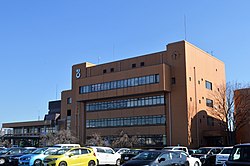
Tōgō, Aichi
Tōgō
東郷町 | |
|---|---|
 Tōgō Town Office | |
 Location of Tōgō in Aichi Prefecture | |
| Coordinates: 35°05′47.9″N 137°03′9.1″E / 35.096639°N 137.052528°E | |
| Country | Japan |
| Region | Chūbu region Tōkai region |
| Prefecture | Aichi |
| District | Aichi |
| Area | |
| • Total | 18.03 km2 (6.96 sq mi) |
| Population (October 1, 2019) | |
| • Total | 44,109 |
| • Density | 2,400/km2 (6,300/sq mi) |
| Time zone | UTC+9 (Japan Standard Time) |
| - Tree | Ternstroemia |
| - Flower | Siberian iris |
| Phone number | 0561-38-3111 |
| Address | Tōgō-chō, Aichi-gun, Aichi-ken 470-0198 |
| Website | Official website |
Tōgō (東郷町, Tōgō-chō) is a town located in Aichi District, Aichi Prefecture, Japan. As of 1 October 2019[update], the town had an estimated population of 44,109 in 17,792 households,[1] and a population density of 2,446 persons per km2. The total area of the town was 18.03 square kilometres (6.96 sq mi).
Geography[edit]
Tōgō is located in approximately the geographic center of Aichi Prefecture, immediately to the east of the Nagoya metropolis. The area is noted for a number of golf courses, including the Nagoya Golf Club's Wago Course, which hosts The Crowns golf tournament.
Neighboring municipalities[edit]
Demographics[edit]
Per Japanese census data,[2] the population of Tōgō has been increasing rapidly over the past 70 years.
| Year | Pop. | ±% |
|---|---|---|
| 1940 | 4,241 | — |
| 1950 | 5,469 | +29.0% |
| 1960 | 6,200 | +13.4% |
| 1970 | 11,509 | +85.6% |
| 1980 | 22,125 | +92.2% |
| 1990 | 30,446 | +37.6% |
| 2000 | 36,878 | +21.1% |
| 2010 | 41,823 | +13.4% |
Climate[edit]
The town has a climate characterized by characterized by hot and humid summers, and relatively mild winters (Köppen climate classification Cfa). The average annual temperature in Tōgō is 15.7 °C. The average annual rainfall is 1593 mm with September as the wettest month. The temperatures are highest on average in August, at around 28.0 °C, and lowest in January, at around 4.2 °C.[3]
History[edit]
The villages of Morowa and Haruki were established within Aichi District, Aichi with the establishment of the modern municipalities system on October 1, 1889. The town villages merged on May 10, 1906 to form the village of Tōgō. It was elevated to town status on April 1, 1970.
Economy[edit]
Tōgō is largely a regional commercial center with some light manufacturing industry. Due to its proximity to the Nagoya metropolis, it is increasingly becoming a commuter town.
Education[edit]
Tōgō has six public elementary schools and three public junior high schools operated by the town government and one public high school operated by the Aichi Prefectural Board of Education. The town also has one private high school.
Transportation[edit]
Railway[edit]
- Tōgō does not have any passenger railway service. The nearest train station is Komenoki Station on the Meitetsu Toyota Line in the neighboring city of Nisshin.
Highway[edit]
Local attractions[edit]

- Kurozasa Nana-go-Kama Kiln
- Yufuku-ji temple
Noted people from Tōgō[edit]
- Stephanie Mawuli, basketball player
- Jiro Sato, actor
- Yoshi-Hashi, professional wrestler (Real Name: Nobuo Yoshihashi, Nihongo: 吉橋 伸雄, Yoshihashi Nobuo)
References[edit]
- ^ Tōgō Town official statistics (in Japanese)
- ^ Tōgō population statistics
- ^ Tōgō climate data
External links[edit]
![]() Media related to Togo, Aichi at Wikimedia Commons
Media related to Togo, Aichi at Wikimedia Commons
- Official website (in Japanese)


