
Lincroft, New Jersey
Lincroft, New Jersey | |
|---|---|
 Entrance to Thompson Park in Lincroft | |
 Location of Lincroft in Monmouth County highlighted in red (left). Inset map: Location of Monmouth County in New Jersey highlighted in orange (right). | |
 Lincroft Location in Monmouth County  Lincroft Location in New Jersey  Lincroft Location in the United States | |
| Coordinates: 40°20′07″N 74°07′58″W / 40.335293°N 74.132838°W | |
| Country | |
| State | |
| County | Monmouth |
| Township | Middletown |
| Area | |
| • Total | 5.79 sq mi (15.01 km2) |
| • Land | 5.58 sq mi (14.46 km2) |
| • Water | 0.21 sq mi (0.55 km2) 3.78% |
| Elevation | 64 ft (14 m) |
| Population | |
| • Total | 7,060 |
| • Density | 1,264.8/sq mi (488.32/km2) |
| Time zone | UTC−05:00 (Eastern (EST)) |
| • Summer (DST) | UTC−04:00 (Eastern (EDT)) |
| ZIP Code | 07738[4] |
| Area code(s) | 732/848 |
| FIPS code | 34-40320[5][6][7] |
| GNIS feature ID | 2390072[5][8] |
Lincroft is an unincorporated community and census-designated place (CDP)[9] within Middletown Township, in Monmouth County, in the U.S. state of New Jersey.[10][11][12] As of the 2020 United States census, the CDP had a population of 7,060, reflecting a 15.1% increase from the 6,135 residents enumerated at the 2010 U.S. Census,[13] in turn a decline of 120 residents (-1.9%) from the 6,255 counted in the 2000 U.S. Census.
Geography[edit]
According to the U.S. Census Bureau, Lincroft had a total area of 5.799 square miles (15.019 km2), including 5.580 square miles (14.452 km2) of land and 0.219 square miles (0.567 km2) of water (3.78%).[5][14]
Demographics[edit]

| Census | Pop. | Note | %± |
|---|---|---|---|
| 1990 | 6,193 | — | |
| 2000 | 6,255 | 1.0% | |
| 2010 | 6,135 | −1.9% | |
| 2020 | 7,060 | 15.1% | |
| Population sources: 2090-2010[10] 2000[15] 2010[13] 2020[3] | |||
2010 census[edit]
The 2010 United States census counted 6,135 people, 2,102 households, and 1,675 families in the CDP. The population density was 1,099.5 per square mile (424.5/km2). There were 2,159 housing units at an average density of 386.9 per square mile (149.4/km2). The racial makeup was 94.77% (5,814) White, 0.52% (32) Black or African American, 0.00% (0) Native American, 3.26% (200) Asian, 0.00% (0) Pacific Islander, 0.23% (14) from other races, and 1.22% (75) from two or more races. Hispanic or Latino of any race were 3.55% (218) of the population.[13]
Of the 2,102 households, 39.3% had children under the age of 18; 71.4% were married couples living together; 6.3% had a female householder with no husband present and 20.3% were non-families. Of all households, 18.2% were made up of individuals and 13.8% had someone living alone who was 65 years of age or older. The average household size was 2.89 and the average family size was 3.29.[13]
26.7% of the population were under the age of 18, 5.5% from 18 to 24, 19.1% from 25 to 44, 31.8% from 45 to 64, and 16.9% who were 65 years of age or older. The median age was 44.2 years. For every 100 females, the population had 93.4 males. For every 100 females ages 18 and older there were 92.3 males.[13]
2000 census[edit]
As of the 2000 United States census[6] there were 6,255 people, 2,121 households, and 1,718 families living in the CDP. The population density was 1,113.0 inhabitants per square mile (429.7/km2). There were 2,160 housing units at an average density of 384.3 per square mile (148.4/km2). The racial makeup of the CDP was 93.11% White, 0.83% African American, 0.08% Native American, 4.52% Asian, 0.66% from other races, and 0.80% from two or more races. Hispanic or Latino of any race were 2.54% of the population.[15]
There were 2,121 households, out of which 41.6% had children under the age of 18 living with them, 73.8% were married couples living together, 5.3% had a female householder with no husband present, and 19.0% were non-families. 17.3% of all households were made up of individuals, and 12.8% had someone living alone who was 65 years of age or older. The average household size was 2.91 and the average family size was 3.31.[15]
In the CDP the population was spread out, with 28.1% under the age of 18, 5.2% from 18 to 24, 25.4% from 25 to 44, 27.6% from 45 to 64, and 13.7% who were 65 years of age or older. The median age was 40 years. For every 100 females, there were 97.3 males. For every 100 females age 18 and over, there were 94.0 males.[15]
The median income for a household in the CDP was $94,199, and the median income for a family was $104,972. Males had a median income of $79,177 versus $41,875 for females. The per capita income for the CDP was $37,910. About 3.0% of families and 5.6% of the population were below the poverty line, including 4.5% of those under age 18 and 14.0% of those age 65 or over.[15]
Education[edit]

Lincroft is home to several schools, including:
- Brookdale Community College, the community college of Monmouth County[16]
- Christian Brothers Academy is an all-boys College preparatory school with a focus on Christian education run by the Institute of the Brothers of the Christian Schools[17]
- High Technology High School, a vocational school situated on the Brookdale Campus[18]
- Lincroft Elementary School, a public K-5 elementary school operating under the Middletown Township Public School District[19]
- Oak Hill Academy, a private, nonsectarian elementary school for grades K-8 founded in 1981.[20]
- St. Leo the Great School, a private Catholic elementary school (K-8) operated by the Roman Catholic Diocese of Trenton that was recognized in 2012 by the National Blue Ribbon Schools Program.[21][22]
Historic district[edit]
Brookdale Farm Historic District | |
 Training Stable at Brookdale Farm | |
| Location | 805 Newman Springs Road |
|---|---|
| Area | 228 acres (92 ha) |
| NRHP reference No. | 100004105[23][24] |
| NJRHP No. | 3360[25] |
| Significant dates | |
| Added to NRHP | November 9, 2020 |
| Designated NJRHP | May 9, 2019 |
Brookdale Farm is a 228-acre (0.92 km2) historic district encompassing the core part of the farm. It was added to the National Register of Historic Places on November 9, 2020, for its significance in agriculture, architecture and entertainment/recreation from 1786 to 1932. The district has 19 contributing buildings and one contributing site.[26]
-
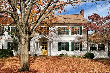 Thomas Lloyd House
 -
 Lloyd Barn (right) and Ten Mare Barn (left)


Transportation[edit]
New Jersey Transit offers local bus service on the 833 route. NJ Transit train service on the North Jersey Coast Line is available at the Red Bank station.[27]
Notable people[edit]
People who were born in, residents of, or otherwise closely associated with Lincroft include:
- Sebastian Bach (born 1968), lead singer, Skid Row[28]
- Nicole Byer (born 1986), comedian[29]
- Vincent Favale (born 1959), co-founder of Comedy Central.[30]
- Bob Tucker (born 1945), former professional football player, Minnesota Vikings and New York Giants[31]
References[edit]
- ^ "ArcGIS REST Services Directory". United States Census Bureau. Retrieved October 11, 2022.
- ^ U.S. Geological Survey Geographic Names Information System: Lincroft Census Designated Place, Geographic Names Information System. Accessed June 28, 2012.
- ^ a b QuickFacts Lincroft CDP, New Jersey, United States Census Bureau. Accessed June 22, 2023.
- ^ Look Up a ZIP Code for Lincroft, NJ, United States Postal Service. Accessed June 28, 2012.
- ^ a b c Gazetteer of New Jersey Places, United States Census Bureau. Accessed July 21, 2016.
- ^ a b U.S. Census website, United States Census Bureau. Accessed September 4, 2014.
- ^ Geographic codes for New Jersey, Missouri Census Data Center. Accessed June 9, 2023.
- ^ US Board on Geographic Names, United States Geological Survey. Accessed September 4, 2014.
- ^ State of New Jersey Census Designated Places - BVP20 - Data as of January 1, 2020, United States Census Bureau. Accessed December 1, 2022.
- ^ a b New Jersey: 2010 - Population and Housing Unit Counts - 2010 Census of Population and Housing (CPH-2-32), United States Census Bureau, August 2012. Accessed December 16, 2012.
- ^ GCT-PH1 - Population, Housing Units, Area, and Density: 2010 - County -- County Subdivision and Place from the 2010 Census Summary File 1 for Monmouth County, New Jersey Archived 2020-02-12 at archive.today, United States Census Bureau. Accessed December 16, 2012.
- ^ Locality Search, State of New Jersey. Accessed April 19, 2015.
- ^ a b c d e DP-1 - Profile of General Population and Housing Characteristics: 2010 Demographic Profile Data for Lincroft CDP, New Jersey, United States Census Bureau. Accessed June 28, 2012.
- ^ US Gazetteer files: 2010, 2000, and 1990, United States Census Bureau. Accessed September 4, 2014.
- ^ a b c d e DP-1 - Profile of General Demographic Characteristics: 2000 from the Census 2000 Summary File 1 (SF 1) 100-Percent Data for Lincroft CDP, New Jersey Archived 2020-02-12 at archive.today, United States Census Bureau. Accessed December 16, 2012.
- ^ Lincroft Campus Archived 2016-06-04 at the Wayback Machine, Brookdale Community College. Accessed May 17, 2017.
- ^ Our History Archived 2015-09-30 at the Wayback Machine, Christian Brothers Academy. Accessed September 18, 2015.
- ^ School Profile, High Technology High School. Accessed September 18, 2015.
- ^ Lincroft Elementary School, Middletown Township Public School District. Accessed September 18, 2015.
- ^ History and Philosophy, Oak Hill Academy. Accessed January 28, 2018. "Using the facilities of the Unitarian Church on West Front Street in Lincroft, New Jersey, Oak Hill Academy opened its doors in September of 1981 to students in seventh and eighth grades. In 1984, the school, now including a sixth grade, moved to a ten-acre campus on Middletown-Lincroft Road in Lincroft."
- ^ Monmouth County Elementary Schools, Roman Catholic Diocese of Trenton. Accessed January 28, 2018.
- ^ Our History, St. Leo the Great School. Accessed September 5, 2014.
- ^ "National Register Information System – (#100004105)". National Register of Historic Places. National Park Service. November 2, 2013.
- ^ "Weekly List 20201113". National Park Service. November 13, 2020.
- ^ "New Jersey and National Registers of Historic Places – Monmouth County" (PDF). New Jersey Department of Environmental Protection – Historic Preservation Office. September 29, 2022. p. 12.
- ^ Zink, Clifford (December 2018). National Register of Historic Places Registration: Brookdale Farm Historic District (Draft) (PDF). National Park Service. With accompanying 102 photos.
- ^ Monmouth County Bus / Rail Connections, New Jersey Transit, backed up by the Internet Archive as of July 26, 2010. Accessed August 8, 2012.
- ^ Hyman, Vicki. "Skid Row's Sebastian Bach sells Lincroft home, says Jersey 'haunted' for him now", NJ Advance Media for NJ.com, January 21, 2016. Accessed May 17, 2017. "Sebastian Bach, the Skid Row frontman who made New Jersey his home for 21 years, has finally sold the Lincroft home that was condemned after massive flooding from Hurricane Irene in 2011, and tells NJ Advance Media what New Jersey has meant to him -- and why he had to move on."
- ^ Lutes, Alicia. "16 Smart Questions for Nicole Byer", Amy Poehler's Smart Girls, September 29, 2015. Accessed January 14, 2019. "Hometown: Lincroft, New Jersey… Monmouth County"
- ^ Josselyn, Jim. "Funny Guy Vinnie Favale’s improbable journey from one night of standup to long-standing gigs with Letterman and Colbert.", New Jersey Monthly, October 8, 2016. Accessed September 19, 2019. "Along the way, the 57-year-old Favale, who lives in Lincroft, worked for a variety of media companies, helped launch VH1 and became a regular guest on Howard Stern’s radio show."
- ^ Harvin, Al. "An Offseason Game; New Jersey Sports", The New York Times, January 12, 1973. Accessed May 7, 2017. "Some of the other Jersey residents on the team, according to Davis, are Bob Tucker, the New York Giants' tight end from Lincroft; Phil Villapiano, Oakland Raider linebacker from Ocean Township, and Ron Johnson, Giant running back, now a resident of Fort Lee."
| Neighborhoods |  | |
|---|---|---|
| Schools | ||
| Parks and recreation | ||
| NRHP sites | ||
| Public transportation | ||
| Roads and highways | ||
| Other points of interest | ||
This list is incomplete. | ||

| International | |
|---|---|
| National | |
| Geographic | |