
Rainbow Bridge (Niagara Falls)
Rainbow Bridge | |
|---|---|
 Rainbow Bridge, viewed from Ontario | |
| Coordinates | 43°05′25″N 79°04′04″W / 43.0902°N 79.0677°W |
| Carries | 4 lanes of |
| Crosses | Niagara River |
| Locale | Niagara Falls, Ontario, Canada and Niagara Falls, New York, U.S. |
| Official name | Niagara Falls International Rainbow Bridge |
| Maintained by | Niagara Falls Bridge Commission |
| Characteristics | |
| Design | Arch bridge of steel construction |
| Total length | 1,450 ft (440 m)[1] |
| Height | 202 ft (62 m)[1] |
| Longest span | 960 ft (290 m)[1] |
| History | |
| Construction cost | $4 million[1] |
| Opened | November 1, 1941 |
| Statistics | |
| Toll | Canada-bound only: $5.00 USD or $6.50 CAD per auto. $1.00 USD or $1.00 CAD per pedestrian/bicyclist.[2] |
| Location | |
 | |
The Niagara Falls International Rainbow Bridge, commonly known as the Rainbow Bridge, is a steel arch bridge across the Niagara River, connecting the cities of Niagara Falls, New York, United States, and Niagara Falls, Ontario, Canada.
Construction[edit]
The Rainbow Bridge was built near the site of the earlier Honeymoon Bridge, which collapsed in 1938 due to an ice jam in the Niagara Gorge.
Architect Richard (Su Min) Lee designed the bridge; a design also used for the Lewiston-Queenston Bridge, approximately 10 kilometres (6 mi) downriver. The bridge's Rainbow Tower and Canadian side plaza are the work of Canadian other architect William Lyon Somerville.[3] King George VI and Queen Elizabeth, during their visit to Niagara Falls as part of their 1939 royal tour of Canada, dedicated the future construction site of the Rainbow Bridge; a monument was later erected to commemorate the occasion. Construction began in May 1940. The bridge officially opened on November 1, 1941.[4]
The Niagara Falls Bridge Commission chose the name "Rainbow Bridge" in March 1939, because rainbows occur frequently near the falls due to water spray and mist in the air.[5]
Description and specifications[edit]
The New York State Department of Transportation designates the bridge as NY 955A, an unsigned reference route. Roads that adjoin the bridge include New York routes 104 and 384, and the Niagara Scenic Parkway. The Ontario Ministry of Transportation designates the bridge as part of Highway 420. The Rainbow Tower, part of the plaza complex on the Canadian side, houses a carillon, which plays several times daily.
The Rainbow Bridge does not permit commercial trucks; the nearest border crossing accessible to trucks is the Lewiston-Queenston Bridge.[6]
2023 car crash[edit]
On November 22, 2023, a car traveling at a high rate of speed left the roadway, went airborne, crashed and exploded at the Rainbow Bridge border crossing on the American side, killing the vehicle's two occupants, and injuring a U.S. Customs and Border Protection officer.[7] The crash and subsequent explosion was at first investigated as a potential terrorist attack, and was later determined to have been an accident.[8]

Gallery[edit]
-
 The bridge as viewed from Canada, with collapsed Schoellkopf Power Station visible in the distance
 -
 Bridge and the American Falls at night
 -
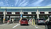 The border station to enter Canada after crossing the bridge from the US
 -
 Directions to the US for internationally destined pedestrians


_Border_Station.jpg)

See also[edit]
- List of bridges documented by the Historic American Engineering Record in New York
- List of bridges in Canada
- List of bridges in the United States by height
- List of crossings of the Niagara River
- List of reference routes in New York
References[edit]
- ^ a b c d "Celebrating Eight Decades of Award-winning Bridges" (PDF). Modern Steel Construction. American Institute of Steel Construction. November 2011. p. 23 (page 2 in PDF). Retrieved April 30, 2019.
- ^ "Niagara Falls Bridge Commission: Toll Cost & Vehicle Definitions". August 1, 2022. Retrieved 2023-09-24.
- ^ "Somerville, William Lyon". Biographical Dictionary of Architects in Canada 1800–1950. Retrieved August 23, 2017.
- ^ Woyce, Kevin (2015). Niagara: The Falls and the River: An Illustrated History. Kevin Woyce. ISBN 978-0692522523.
- ^ Stamp, Robert M. (1992). Bridging the Border: Structures of Canadian–American Relations. Toronto: Dundurn Press. p. 128. ISBN 1-55002-074-9.
- ^ "Niagara Falls Bridge Commission: Which Bridge Do I Take?".
- ^ Tabachnick, Cara (2023-11-24). "2 dead in vehicle explosion at Rainbow Bridge U.S.-Canada border crossing; officials say no sign of terrorism". CBS News. Retrieved 2023-11-25.
- ^ Tebor, Celina; Miller, John; Perez, Evan; Sanchez, Ray (2023-11-23). "Sources: Deadly crash at US-Canadian border bridge involved husband and wife in a Bentley, investigators believe". CNN. Retrieved 2024-01-11.
He called the crash a "tragic accident."
External links[edit]
- Niagara Falls Bridge Commission
- Google Maps view of Rainbow Bridge
- Live Traffic Camera of Rainbow Bridge
- Images from the Historic Niagara Digital Collections
- Historic American Engineering Record (HAER) No. NY-551, "Rainbow Bridge, Spanning Niagara River, Niagara Falls, Niagara County, NY", 2 photos, 1 photo caption page
Bridges of the Niagara River | ||||
|---|---|---|---|---|
| ||||
- 1941 establishments in New York (state)
- 1941 establishments in Ontario
- Bridges completed in 1941
- Bridges in Niagara Falls, New York
- Bridges in Niagara Falls, Ontario
- Bridges over the Niagara River
- Canada–United States border crossings
- Historic American Engineering Record in New York (state)
- Open-spandrel deck arch bridges in Canada
- Open-spandrel deck arch bridges in the United States
- Road bridges in New York (state)
- Road bridges in Ontario
- Toll bridges in Canada
- Toll bridges in New York (state)
- Steel bridges in Canada
- Steel bridges in the United States
- Concrete bridges in Canada
- Concrete bridges in the United States