
Wasco, California
City of Wasco | |
|---|---|
 Water tower in Wasco | |
| Motto: "Grow With Us" | |
 Location in Kern County and the state of California | |
 City of Wasco Location in the United States | |
| Coordinates: 35°35′39″N 119°20′27″W / 35.59417°N 119.34083°W | |
| Country | |
| State | |
| County | Kern |
| Incorporated | December 22, 1945[1] |
| Named for | Sources unclear, either Wasco County, Oregon or Western American Sugar Company |
| Government | |
| • State senator | Anna Caballero (D)[2] |
| • Assemblymember | Vince Fong (R)[2] |
| • U. S. Rep. | Jim Costa (D)[3] |
| Area | |
| • Total | 9.39 sq mi (24.32 km2) |
| • Land | 9.39 sq mi (24.32 km2) |
| • Water | 0.00 sq mi (0.00 km2) 0% |
| Elevation | 328 ft (100 m) |
| Population (2010) | |
| • Total | 25,545 |
| • Estimate (2019)[6] | 28,710 |
| • Density | 3,058.16/sq mi (1,180.73/km2) |
| Time zone | UTC-8 (PST) |
| • Summer (DST) | UTC-7 (PDT) |
| ZIP code | 93280 |
| Area code | 661 |
| FIPS code | 06-83542 |
| GNIS feature ID | 1661652 |
| Website | www |
Wasco (formerly, Dewey and Deweyville)[7] is a city in the San Joaquin Valley, in Kern County, California, United States. Wasco is located 24 miles (39 km) northwest of Bakersfield,[7] at an elevation of 328 feet (100 m).[5] The population was 25,545 at the 2010 census, up from 21,263 at the 2000 census.
Wasco is the headquarters of the Tejon Indian Tribe of California, a federally recognized tribe of Kitanemuk, Yokuts, and Chumash indigenous people of California.[8]
History[edit]
The name Dewey was in honor of Admiral George Dewey, a hero of the Spanish–American War.[7] The Deweyville post office opened in 1899, and changed its name to Wasco in 1907.[7]
The origin of the name Wasco is subject of two different theories: (1) That it was coined from Western American Sugar Company; and (2) that it was named by a resident from Wasco County, Oregon.[7]
Wasco is the site of the Fourth Home Extension Colony, founded in 1907 by the American Home Extension Association.[7]
Geography[edit]
According to the United States Census Bureau, the city has a total area of 9.4 square miles (24 km2), all of it land. At the 2000 census, according to the United States Census Bureau, the city had a total area of 7.6 square miles (20 km2), all of it land. Wasco is located on the floor of the San Joaquin Valley, at the intersection of California State Routes 43, which runs north–south, and 46, which runs east–west.
-
 Amtrak station, January 2014
 -
 City Hall, December 2010
 -
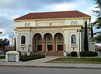 The Wasco Union High School Auditorium is on the National Register of Historic Places.


Climate[edit]
According to the Köppen Climate Classification system, Wasco has a semi-arid climate (BSk, bordering on BSh) with extremely hot, dry summers and mild to cool winters. The average annual mean temperature is 64.1 °F (17.8 °C).
| Climate data for Wasco, California (1991–2020 normals, extremes 1901–present) | |||||||||||||
|---|---|---|---|---|---|---|---|---|---|---|---|---|---|
| Month | Jan | Feb | Mar | Apr | May | Jun | Jul | Aug | Sep | Oct | Nov | Dec | Year |
| Record high °F (°C) | 81 (27) |
86 (30) |
100 (38) |
102 (39) |
109 (43) |
113 (45) |
116 (47) |
115 (46) |
113 (45) |
110 (43) |
92 (33) |
85 (29) |
116 (47) |
| Mean maximum °F (°C) | 70.6 (21.4) |
76.0 (24.4) |
83.4 (28.6) |
92.2 (33.4) |
100.1 (37.8) |
106.3 (41.3) |
107.6 (42.0) |
107.3 (41.8) |
104.1 (40.1) |
94.8 (34.9) |
80.1 (26.7) |
70.9 (21.6) |
109.5 (43.1) |
| Mean daily maximum °F (°C) | 58.5 (14.7) |
65.1 (18.4) |
71.3 (21.8) |
77.2 (25.1) |
86.0 (30.0) |
93.9 (34.4) |
100.0 (37.8) |
98.8 (37.1) |
93.5 (34.2) |
82.4 (28.0) |
68.5 (20.3) |
58.6 (14.8) |
79.5 (26.4) |
| Daily mean °F (°C) | 47.6 (8.7) |
52.5 (11.4) |
57.8 (14.3) |
63.2 (17.3) |
71.6 (22.0) |
77.6 (25.3) |
83.4 (28.6) |
81.6 (27.6) |
77.6 (25.3) |
66.8 (19.3) |
55.1 (12.8) |
47.2 (8.4) |
66.0 (18.9) |
| Mean daily minimum °F (°C) | 36.6 (2.6) |
40.0 (4.4) |
44.2 (6.8) |
49.2 (9.6) |
57.3 (14.1) |
61.3 (16.3) |
66.8 (19.3) |
64.4 (18.0) |
59.8 (15.4) |
51.1 (10.6) |
41.7 (5.4) |
35.7 (2.1) |
50.7 (10.4) |
| Mean minimum °F (°C) | 28.2 (−2.1) |
30.7 (−0.7) |
35.2 (1.8) |
38.9 (3.8) |
45.6 (7.6) |
50.7 (10.4) |
58.7 (14.8) |
57.3 (14.1) |
52.1 (11.2) |
40.7 (4.8) |
31.3 (−0.4) |
26.9 (−2.8) |
25.3 (−3.7) |
| Record low °F (°C) | 12 (−11) |
18 (−8) |
20 (−7) |
21 (−6) |
33 (1) |
32 (0) |
46 (8) |
40 (4) |
33 (1) |
25 (−4) |
17 (−8) |
13 (−11) |
12 (−11) |
| Average precipitation inches (mm) | 1.29 (33) |
1.16 (29) |
1.37 (35) |
0.63 (16) |
0.27 (6.9) |
0.13 (3.3) |
0.01 (0.25) |
0.02 (0.51) |
0.03 (0.76) |
0.51 (13) |
0.58 (15) |
1.11 (28) |
7.11 (180.72) |
| Average precipitation days | 6.9 | 6.2 | 5.6 | 3.4 | 1.4 | 0.4 | 0.1 | 0.1 | 0.3 | 1.5 | 3.3 | 5.1 | 34.3 |
| Source: NOAA[9][10] | |||||||||||||
Demographics[edit]
| Census | Pop. | Note | %± |
|---|---|---|---|
| 1950 | 5,592 | — | |
| 1960 | 6,841 | 22.3% | |
| 1970 | 8,269 | 20.9% | |
| 1980 | 9,613 | 16.3% | |
| 1990 | 12,412 | 29.1% | |
| 2000 | 21,263 | 71.3% | |
| 2010 | 25,545 | 20.1% | |
| 2019 (est.) | 28,710 | [6] | 12.4% |
| U.S. Decennial Census[11] | |||
2010[edit]
At the 2010 census Wasco had a population of 25,545. The population density was 2,710.1 inhabitants per square mile (1,046.4/km2). The racial makeup of Wasco was 12,579 (49.2%) White, 1,951 (7.6%) African American, 283 (1.1%) Native American, 180 (0.7%) Asian, 12 (0.0%) Pacific Islander, 9,714 (38.0%) from other races, and 826 (3.2%) from two or more races. Hispanic or Latino of any race were 19,585 persons (76.7%).[12]
The census reported that 19,825 people (77.6% of the population) lived in households, 10 (0%) lived in non-institutionalized group quarters, and 5,710 (22.4%) were institutionalized.
There were 5,131 households, 3,143 (61.3%) had children under the age of 18 living in them, 2,894 (56.4%) were opposite-sex married couples living together, 992 (19.3%) had a female householder with no husband present, 484 (9.4%) had a male householder with no wife present. There were 478 (9.3%) unmarried opposite-sex partnerships, and 27 (0.5%) same-sex married couples or partnerships. 575 households (11.2%) were one person and 243 (4.7%) had someone living alone who was 65 or older. The average household size was 3.86. There were 4,370 families (85.2% of households); the average family size was 4.11.
The age distribution was 7,351 people (28.8%) under the age of 18, 3,687 people (14.4%) aged 18 to 24, 8,621 people (33.7%) aged 25 to 44, 4,593 people (18.0%) aged 45 to 64, and 1,293 people (5.1%) who were 65 or older. The median age was 28.3 years. For every 100 females, there were 160.3 males. For every 100 females age 18 and over, there were 192.5 males.
There were 5,477 housing units at an average density of 581.1 per square mile, of the occupied units 2,680 (52.2%) were owner-occupied and 2,451 (47.8%) were rented. The homeowner vacancy rate was 5.1%; the rental vacancy rate was 4.0%. 10,486 people (41.0% of the population) lived in owner-occupied housing units and 9,339 people (36.6%) lived in rental housing units.
2000[edit]
At the 2000 census there were 21,263 people in 3,971 households, including 3,403 families, in the city. The population density was 2,795.7 inhabitants per square mile (1,079.4/km2). There were 4,256 housing units at an average density of 559.6 per square mile (216.1/km2). The racial makeup of the city was 34.64% White, 10.27% Black or African American, 1.02% Native American, 0.67% Asian, 0.15% Pacific Islander, 50.46% from other races, and 2.78% from two or more races. 66.72% of the population were Hispanic or Latino of any race.[13] Of the 3,971 households 55.1% had children under the age of 18 living with them, 62.3% were married couples living together, 16.8% had a female householder with no husband present, and 14.3% were non-families. 11.6% of households were one person and 5.7% were one person aged 65 or older. The average household size was 3.79 and the average family size was 4.07.
The age distribution was 27.4% under the age of 18, 13.9% from 18 to 24, 39.4% from 25 to 44, 13.8% from 45 to 64, and 5.4% 65 or older. The median age was 29 years. For every 100 females, there were 183.5 males. For every 100 females age 18 and over, there were 230.6 males.
The median income for a householder in the city was $28,997, and the median family income was $30,506. Males had a median income of $48,105 versus $18,697 for females. The per capita income for the city was $14,228. About 24.3% of families and 27.5% of the population were below the poverty line, including 35.3% of those under age 18 and 10.1% of those age 65 or over.
People in group quarters[edit]
Source:[14]
- 7,975 people in Wasco State Prison
- 1,226 people in other types of correctional institutions
- 10 people in homes for the mentally ill
- 8 people in other non-institutional group quarters
Economy[edit]

One of Wasco's major economic activities is agriculture, specifically the growing of roses. Fifty-five percent of all roses grown in the United States are grown in or around Wasco.[15]
In addition to agriculture, oil and gas extraction is a significant part of the local economy. The large Semitropic Oil Field is along State Route 46 about 7 miles (11 km) west of town. Formerly a gas field, the region now mainly produces oil. Vintage Production, an arm of Occidental Petroleum, is the primary operator as of 2010.
The Wasco Oil Field was discovered in April 1938, by Continental Oil Company.[16]
Sports[edit]
The Wasco Reserve (called the Reserves in their 2019 debut season[17]) were a professional baseball team competing in the independent Pecos League which is not affiliated with Major League Baseball or Minor League Baseball. Their home games through the 2021 season were played at Wasco Athletic Park, sharing Bakersfield's Sam Lynn Ballpark for their 2022 final season.[18]
Transportation[edit]
The Amtrak service, the San Joaquins, stops at the Wasco station, which has one platform next to the single track; the station building was demolished in 2021. Being on the route of the high speed rail project without a stop, Wasco city officials have expressed concerns that the Amtrak service might be discontinued.[19] As of August 2020[update], no decision has been announced.[20] The construction has impacted the city and the costs for asbestos removal are in dispute in a labor housing complex that had to be abandoned and demolished.[21] While paid relocation costs, the city can’t afford to demolish the camp and wants the rail authority to pay. Chief Executive Brian Kelly came to the city to discuss the issue in 2021.[22]
Notable people[edit]
- Pablo Garza, American mixed martial artist
- Suzanne Lacy, artist and educator
- Aaron Merz, former American football offensive lineman
- Jim Napier, former minor league baseball catcher and manager
- Manuel Quezada, professional boxer
- Carl Smith, American football coach
In popular culture[edit]
The town is featured in Episode 133 of California's Gold with Huell Howser, filmed in 2007.[23]
In the movie "Son in Law" featuring comedian Pauly Shore, the opening credit flyover shots and the opening graduation scene, were filmed in Wasco, CA and at the Wasco High School football stadium respectively.[24]
See also[edit]
- Alpaugh, California
- M.V. Hartranft, land developer in Wasco
References[edit]
- ^ "California Cities by Incorporation Date". California Association of Local Agency Formation Commissions. Archived from the original (Word) on November 3, 2014. Retrieved August 25, 2014.
- ^ a b "Statewide Database". UC Regents. Archived from the original on February 1, 2015. Retrieved November 23, 2014.
- ^ "California's 21st Congressional District - Representatives & District Map". Civic Impulse, LLC.
- ^ "2019 U.S. Gazetteer Files". United States Census Bureau. Retrieved July 1, 2020.
- ^ a b U.S. Geological Survey Geographic Names Information System: Wasco, California
- ^ a b "Population and Housing Unit Estimates". United States Census Bureau. May 24, 2020. Retrieved May 27, 2020.
- ^ a b c d e f Durham, David L. (1998). California's Geographic Names: A Gazetteer of Historic and Modern Names of the State. Clovis, Calif.: Word Dancer Press. ISBN 1-884995-14-4.
- ^ Edelhart, Courtenay. "Tejon tribe fought for recognition throughout history." Archived 2013-11-03 at the Wayback Machine The Bakersfield Californian. 5 March 2012. Retrieved 23 April 2013.
- ^ "Wasco – NWS Hanford CA NOAA Online Weather Data". Retrieved February 10, 2021.
- ^ "U.S. Climate Normals Quick Access – Station: Wasco, CA". National Oceanic and Atmospheric Administration. Retrieved May 27, 2023.
- ^ "Census of Population and Housing". Census.gov. Retrieved June 4, 2015.
- ^ "2010 Census Interactive Population Search: CA - Wasco city". U.S. Census Bureau. Archived from the original on July 15, 2014. Retrieved July 12, 2014.
- ^ "U.S. Census website". United States Census Bureau. Retrieved January 31, 2008.
- ^ "City-data - People in group quarters / Wasco - California". analyzed data from numerous sources. Retrieved March 17, 2009.
- ^ "City of Wasco, CA - Festival of Roses". Archived from the original on August 13, 2007. Retrieved November 7, 2007.
- ^ Barnes, Roy (1943). Wasco Oil Field, in Geologic Formations and economic development of the Oil and Gas Fields of California. San Francisco: State of California Dept. of Natural Resources Division of Mines, Bulletin 118. p. 553.
- ^ "Wasco Reserves will now be known as Wasco Reserve effectively immediately". Pecos Leage of Professional Baseball Clubs. Retrieved March 31, 2024.
- ^ Jacuinde, Veronica (May 10, 2022). "Reserve will play this year, but not in Wasco". Wasco Tribune. Retrieved March 31, 2024.
- ^ "City of Wasco speaks out against High Speed Rail Authority". The Bakersfield Californian. August 13, 2020. Retrieved August 13, 2020.
- ^ Hewerdine, Makayla (August 13, 2020). "City of Wasco speaks of challenges High Speed Rail is posing to their community". KERO-TV. Retrieved August 14, 2020.
- ^ Westfall, Austin (December 3, 2020). "High-Speed Rail construction in full swing in Wasco". KERO. Retrieved December 4, 2020.
- ^ Vartabedian, Ralph (October 29, 2021). "Bullet train leaves a trail of grief among the disadvantaged of the San Joaquin Valley". Los Angeles Times. Retrieved November 11, 2021.
- ^ "Wasco – California's Gold (133) – Huell Howser Archives at Chapman University".
- ^ "Son in Law (1993) - IMDb". IMDb.
External links[edit]

| International | |
|---|---|
| National | |
| Other | |