
Tiu Keng Leng
Tiu Keng Leng
調景嶺 | |
|---|---|
Area | |
 Tiu Keng Leng was rebuilt and transformed from a squatter area to a high-rise housing estate | |
 Tiu Keng Leng Location in Hong Kong | |
| Coordinates: 22°18′21″N 114°15′08″E / 22.30583°N 114.25222°E | |
| Established | 26 June 1950 |
| Tiu Keng Leng | |||||||||||||||
|---|---|---|---|---|---|---|---|---|---|---|---|---|---|---|---|
| Traditional Chinese | 調景嶺 | ||||||||||||||
| Simplified Chinese | 调景岭 | ||||||||||||||
| Cantonese Yale | tìuh gíng léhng | ||||||||||||||
| Jyutping | Tiu4 Ging2 Leng5 | ||||||||||||||
| |||||||||||||||
Tiu Keng Leng (Chinese: 調景嶺), formerly[citation needed] Rennie's Mill, is an area of Hong Kong in the Sai Kung District adjacent to Tseung Kwan O (Junk Bay).
The area used to be a refugee village housing former Kuomintang officials and followers who escaped to Hong Kong from Mainland China after the establishment of the People's Republic of China (PRC); however, the original Tiu Keng Leng village was cleared before Hong Kong's sovereignty transfer to the PRC in 1997, and nowadays Tiu Keng Leng is thoroughly redeveloped as part of the Tseung Kwan O New Town.
History[edit]
This section needs additional citations for verification. (August 2023) |
The earliest traceable name referring to the area nowadays known as Tiu Keng Leng was "Chiu Keng Leng" (照鏡嶺, lit. ridge of mirror reflection), being a reference to the clearness and calmness of the adjacent bay. The name was given by Tanka residents in the area.


Both the names "Tiu Keng Leng" and "Rennie's Mill" come from a 19th-century Canadian businessman named Alfred Herbert Rennie, who established the Hong Kong Milling Company at Junk Bay (his partners were Paul Chater and Hormusjee Naorojee Mody). The business failed, and Rennie drowned himself there in 1908, though it was mistakenly reported that he had hanged himself. The incident gave the Chinese name for the site 吊頸嶺 (Tiu Keng Leng / Jyutping: diu3 geng2 leng5), meaning "Hanging (neck) Ridge", a pun on the name "Chiu Keng Leng" mentioned above. Because it was inauspicious, the name was later changed to similar-sounding 調景嶺 (Tiu King Leng / Jyutping: tiu4 ging2 leng5, which can be interpreted as "ridge of adjusting situation".)


On 26 June 1950 the Hong Kong Government's Social Welfare Office (the predecessor of the Social Welfare Department) settled a considerable number of refugees from China – former Nationalist soldiers and other Kuomintang supporters (according to official government account, there were 6,800 of them) – at Rennie's Mill, following the Chinese Civil War.[1] With the newly built temporary settlements, the colonial government provided food and living expenses to the refugees.[2] The Hong Kong Government's original intention was to settle these refugees temporarily before they would be repatriated to Taiwan by the Kuomintang or to Mainland China by the Chinese Communists. But this day never came for the Kuomintang (under the auspices of a political-oriented charitable body named Free China Relief Association which became prominent after the government suspended food ration in 1953), the residents of the enclave became more supportive to the Kuomintang cause. Thus, by the late-1950s, in correlation with the Cold War context in Asia at the time, Rennie's Mill gradually became a "Bastion Against Communism", with the flag of the Republic of China flying (earning it the sobriquet "Little Taiwan"), its own school system and practically off-limits to the Royal Hong Kong Police Force until 1962 when the Hong Kong Government decided to turn it into a resettlement estate due to its apprehension of the growing Kuomintang presence in the enclave. It also had a significant missionary presence. Due to its pro-Kuomintang atmosphere, the 1967 Riots did not have an effect on Rennie's Mill.
Rennie's Mill was badly damaged by Typhoon Wanda in 1962, rendering many homeless.[3]
In 1996 the Hong Kong government evicted the last of Rennie's Mill's original residents, ostensibly to make room for new town developments as part of the Tseung Kwan O New Town, but widely believed to be a move to please the Communist Chinese government before the transfer of sovereignty over Hong Kong in 1997.[citation needed]
Earlier in 1961, the people of Rennie's Mill were promised by the government that they would be able to stay "indefinitely," and in June 1996, residents petitioned the High Court, where judge Raymond Sears found that "In my judgment, the conduct of the Housing Authority by serving notices to quit, in breach of the clear promises of 1961, amounts to an abuse of power."[4]
-
 Hong Kong Milling Company in 1910s
 -
 Rennie's Mill in 1950s
 -
 Rennie's Mill in 1955
 -
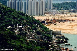 Rennie's Mill in 1995
 -
 Tiu Keng Leng and Tseung Kwan O South in 2019


Housing[edit]

After the handover, the English name of the area was changed from "Rennie's Mill" to "Tiu Keng Leng", following the Cantonese name. Tiu Keng Leng became redeveloped as a modern high-rise residential district.
Metro Town is a private housing estate situated directly above the Tiu Keng Leng Station. With nine towers built on top of a carpark/shopping mall podium, it is the tallest structure in the area.
To the south of Metro Town, on the site of a former steel mill operated by Shiu Wing Steel, is another private housing estate, Ocean Shores.
The three public housing estates in the area are: Kin Ming Estate, Choi Ming Court and Shin Ming Estate.
Transport[edit]
Before the redevelopment and reclamation in the surrounding area, Tiu Keng Leng could be reached by the winding, hilly and narrow Po Lam Road South, which ran past numerous busy quarries. At that time, Tiu Keng Leng's only public transport connections were Kowloon Motor Bus routes 90 and 290, served with minibuses, and by water transport. In 2001, with the redevelopment, a segment of Po Lam Road South was rebuilt and extended to near Kwong Tin Estate in Yau Tong. The reconstructed road was renamed O King Road and became the first road connection to modern Tiu Keng Leng. Tseung Kwan O-Lam Tin Tunnel, opened in 2022, provides a direct and fast route into Kowloon and the city centre.[5][better source needed]
The various centres of Tseung Kwan O were always intended to be served primarily by the MTR metro system,[6] and the 2002 opening of Tiu Keng Leng station of the Tseung Kwan O line and Kwun Tong line provided a much-used link to the urban area of Kowloon.
Education[edit]

The Hong Kong Design Institute (HKDI) is well known for the shape of its building. Designed by French architects Coldefy & Associs, it resembles a piece of paper floating mid-air featuring a glazed box raised seven storeys above the ground on four lattice-steel towers that rest on a sloping, grass-covered podium. Total construction cost amounted to HK$1.2 billion, it was opened in November 2010.
The Hong Kong Institute of Vocational Education (IVE) – Lee Wai Lee campus is located next to HKDI. Also, the campus of Caritas Institute of Higher Education is located at Tiu Keng Leng. The institute has the aim of becoming the first Catholic University in Hong Kong.
See also[edit]
References[edit]
- ^ Kenneth Lan (2006), Rennie's Mill: the origin and evolution of a special enclave in Hong Kong. Ph.D. Thesis, HKU. Accessed 8 August 2023.
- ^ Hu, Yueh (1962). "The Problem of the Hong Kong Refugees". Asian Survey. 2 (1): 33. doi:10.2307/3023656. ISSN 0004-4687. JSTOR 3023656.
- ^ "Many Homeless At Rennie's Mill". South China Morning Post. 4 September 1962. p. 8.
- ^ Gargan, Edward A. (25 July 1996). "Hong Kong Journal;Remnants of Chiang's Army Are Routed Again". The New York Times. ISSN 0362-4331. Retrieved 15 August 2020.
- ^ "Major Projects - Tseung Kwan O – Lam Tin Tunnel". www.cedd.gov.hk. Retrieved 14 June 2020.
- ^ Junk Bay New Town Transport Study·RAIL TRANSPORT – ALTERNATIVE ALIGNMENTS, 1981
External links[edit]
- History Stories: Tiu Keng Leng (part 2)
- Tatlow, Kirsten Didi. "Hong Kong's 'little Taiwan' And Flags Passing Into History." Associated Press at The Day. Monday 29 July 1996. p. A8. Google News page 5/12.
| Areas | |||||
|---|---|---|---|---|---|
| Landmarks |
| ||||
| Education |
| ||||
| MTR stations | |||||
| Media | |||||
| Islands |
| ||||
| History |
| ||||
This list is incomplete. | |||||
| International | |
|---|---|
| National | |