Lesum
| Lesum | |
|---|---|
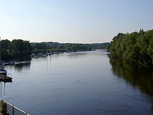
 Mouth of the Lesum near Vegesack | |
| Location | |
| Country | Germany |
| State | Bremen |
| City | Bremen |
| Physical characteristics | |
| Source | |
| • location | Confluence of the Wümme and Hamme rivers near Ritterhude |
| • coordinates | 53°10′17″N 8°44′33″E / 53.17139°N 8.74250°E |
| • elevation | 4 m (13 ft) |
| Mouth | Weser |
• location | Bremen-Vegesack |
• coordinates | 53°10′0″N 8°37′28″E / 53.16667°N 8.62444°E |
• elevation | 4 m (13 ft) |
| Length | 9.85 km (6.12 mi) |
| Basin size | 2,187 km2 (844 sq mi)[1] |
| Basin features | |
| Progression | Weser→ North Sea |
| Tributaries | |
| • left | Wümme |
| • right | Hamme |
The Lesum is a 9.85-kilometre-long (6 mi) river in northern Germany, right tributary of the Weser, navigable for Class III ships.[2] It is formed at the confluence of the rivers Wümme and Hamme, near Ritterhude, northwest of Bremen. It flows west and flows into the Weser in Bremen-Vegesack.
See also[edit]
References[edit]
- ^ Environmental map service of Lower Saxony (Umweltkartendienst des Niedersächsischen Ministeriums für Umwelt, Energie und Klimaschutz)
- ^ Längen der Hauptschifffahrtswege der Binnenwasserstraßen des Bundes, Liste 4, Bundesministerium für Verkehr und digitale Infrastruktur
