
Talk:The Two Georges
| This article is rated Start-class on Wikipedia's content assessment scale. It is of interest to the following WikiProjects: |
||||||||||||||||||
| ||||||||||||||||||

Release dates?[edit]
The release ans award dates (if correct) require time travel.
Anyone know the correct dates? Osprey
- Per the Sidewise Award site, it was indeed nominated for the 1995 award (though it did not, in fact, win it). Per Amazon, the first edition was released March 1, 1996. So I'm confused, too. —Cryptic (talk) 04:49, 5 September 2005 (UTC)
- You know? This one had me stumped as well, until it dawned on me. When you read, Sidewise's website, you'll note the publisher is listed as "Hodder & Staughton", a *British* publisher. Apparently, it was published in the UK first in 1995, before its U.S. debut in March of 1996. See: http://catalogue.bl.uk for details. The book was an interesting read, I remember it. Interesting, a mistake we make often in the USA, assuming a book has been published in this country first. I wonder if the same would have happened in Turtledove's British America, or "North American Union" --Larry G 05:50, 13 November 2005 (UTC) Posting from around New Liverpool <grin>.
Flag[edit]
I have switched the "jack and stripes" used on this page a flag of the British East India Company with the post-1800 Union Jack. According to FOTW, this flag is used in the book; see http://flagspot.net/flags/fic_2g.html#nau. - Thanks, Hoshie 09:33, 8 October 2006 (UTC)
.svg)
I'm sorry,[edit]
But alot of stuff after the plot summary looks like original research and/or questionable. 68.39.174.238 04:22, 30 January 2007 (UTC)
I agree with the above poster. That, and, much of the section "Social and Political Themes" is written in a manner that unfit of an encyclopedia article. The about Martin Luther King are written in a manner best fitting a review of the book, not an encyclopedia article on it. —Preceding unsigned comment added by 69.158.55.245 (talk) 03:52, 8 February 2008 (UTC)
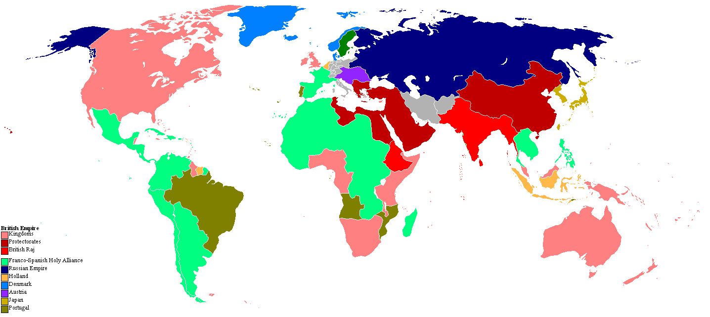
That map is...[edit]
...incorrect, per the authoritative version included in the front of the version I finished reading. The British still have British Guiana, Portugal is evidently independent (Or at least still owns Brazil), all of Africa is listed as belonging to someone, etc, etc. 68.39.174.238 18:26, 25 September 2007 (UTC)
The Road to Wigan Pier[edit]
Not sure where or whether this should be inserted but The Two Georges' scenes of mining life owe a lot to George Orwell's The Road to Wigan Pier. Avalon (talk) 08:58, 21 April 2011 (UTC)
Provinces of the NAU/Edit Request 8/20/14[edit]
- In this book, the North American Union is composed of many provices. Could they be put on the artical in a table, please? I will list the provinces below. Note, OTL means Original Time Line or Our Time Line and ATL means Alternate Time Line. Could a map of the North American Union from the book also be put on Wikipedia on the Two Georges page? 24.147.1.197 (talk) 15:40, 20 August 2014 (UTC)Jacob Chesley
List of Provices[edit]
- These are all of the known provinces of the North American Union. My source was from the Harry Turtledove Wiki. That wiki helped me out with the list. 24.147.1.197 (talk) 15:40, 20 August 2014 (UTC)Jacob Chesley
- Baffin - OTL North West Territories (less the Southeastern section) and northwestern Nunavut aswell as the Victoria and King William Islands.
- Banksia - OTL Yukon.
- Cherokee Nation - OTL northwest Alabama, northern Mississippi, a northeastern part of Louisiana and southeastern Arkansas.
- Connecticut - OTL Connecticut.
- Cranmer - OTL Texas (minus the eastern part) and Oklahoma (minus the southeastern corner). This province is named after Thomas Cranmer.
- Delaware - OTL Delaware.
- Disraeli - OTL southeaster Idaho, eastern Nevada, all of Utah, and western Colorado. This province is named after Benjamin Disraeli.
- Florida - OTL Florida, the extreme southern parts of Alabama and Mississippi bordering the Gulf of Mexico, and the Florida Parishes of Louisiana.
- Franklin - OTL Kentucky. This province is named after Benjamin Franklin.
- Georgia - OTL Georgia and the remaining part of Alabama.
- Hanover - OTL eastern Montana, southwestern South Dakota, all of Wyoming, and eastern Colorado and Nebraska north of the Platte River.
- Hudsonia - OTL Nunavut (minus the northwestern section aswell as the Victorian and King Islands) and the southeastern section of the Northwest Territories.
- Illinois - OTL Illinois.
- Louisiana - OTL Louisiana (minis the Florida Parishes and the northeastern part), a central strip of Mississippi, eastern Texas, southeastern Oklahoma, and a southwestern corner of Arkansas.
- Lower California - OTL Baja California and Baja California Sur.
- Maryland - OTL Maryland.
- Massachusetts - OTL Massachusetts and Maine.
- Mississippi - OTL western Minnesota west of the Mississippi River, southeastern North Dakota, South Dakota east of the Missouri River, and Iowa and Missouri north of the Missouri River.
- Missouri - OTL Missouri south of the Missour River, northern Arkansas, and Kansas and Nebraska south of the Platte River.
- New Brunswick - OTL New Brunswick.
- Newfoundland - OTL Newfoundland and Labrador.
- New Guernsey - OTL Wisconsin, Minnesota east of the Mississippi River, and the Upper Peninsula of Michigan.
- New Hampshire - OTL New Hampshire.
- New Jersey - OTL New Jersey.
- New Scotland - OTL Nova Scotia.
- North Carolina - OTL North Carolina.
- Oregon - OTL Oregon and Washington (state), along with most of Idaho and northwestern Montana.
- Pennsylvania - OTL Pennsylvania.
- Phoenix - OTL Arizona and New Mexico.
- Quebec - OTL Quebec.
- Rhode Island - OTL Rhode Island.
- South Carolina - OTL South Carolina.
- Tennessee - OTL Tennessee.
- The Six Nations - OTL western New York.
- Tippecanoe - OTL Indiana.
- Upper California - OTL California and western Nevada.
- Vancouver - OTL British Colombia.
- Victoria - Although not a province at all, Victoria is the seat of the North American Union Government. It takes up OTL Washington D.C. and is named after Queen Victoria. The city is in Maryland.
- Virginia - Both OTL Virginia and West Virginia.
- Washington - OTL Saskachewan, eastern Montana, western North Dakota, and norhtwestern South Dakota. This province is named after George Washington.
- Wilberforce - OTL Michigan (except the Upper Peninsula).
Well, here is the finished list! I hope someone answers and does my request soon! 24.147.1.197 (talk) 15:40, 20 August 2014 (UTC)Jacob Chesley
 Done Long since done. I almost completely forgot about this comment I left back when I was editing Wikipedia as a wiki contributor under my first IP address. My request ended up being answered by myself under my second IP address! Funny how the time just goes by so fast these days. --JCC the Alternate Historian (talk) 22:02, 14 February 2018 (UTC)
Mess up on Provinces Section[edit]
I was able to put down all of the provinces of the North American Union on the page. However, something messed up and my editing didn't come out like I planed. I thought I set up the table where I put the names of all the provinces in order correctly, but the table still got screwed up somehow. Could someone fix my mess up? --75.68.122.13 (talk) 14:24, 17 January 2015 (UTC)Jacob Chesley the Alternate Historian
Who ever fixed my mess up, thank you very much :)! --75.68.122.13 (talk) 18:56, 29 January 2015 (UTC)Jacob Chesley the Alternate Historian
- It was me - just needed to add a couple of lines to start the table. You're welcome! Robevans123 (talk) 19:04, 29 January 2015 (UTC)
Map/Edit Request 7/29/2016[edit]
Could new map be added to the article? The map of the world that is already on the article is horribly inaccurate to the one on found in the novel. The borders of some of the nations and colonies and wrong and a few of those colonies and shown to be part of the wrong European power. The map in the link below me is much cleaner and more accurate.
--75.68.122.13 (talk) 15:27, 29 July 2016 (UTC)Jacob Chesley the Alternate Historian
Why I changed the categories[edit]
While the novel was first published in the U.K. (which is why I left it in 1995 British novels), the authors are both very American authors. It just happened that for logistic reasons related to the two publishers' schedules, the U.K. edition technically came out first. The authors are Yanks, the sales of the U.S. edition were much higher, etc. It is extremely misleading to categorize this as a British book in any way except "the first edition is the U.K. edition". --Orange Mike | Talk 02:38, 5 January 2018 (UTC)
Agreed Hugo999 (talk) 22:19, 5 January 2018 (UTC)
Very Inaccurate Map/Request for a Better Map 2/15/2018[edit]
The map that is shown here on the Two Georges article here on Wikipedia (originally on Wikimedia) is very incorrect and outdated. In fact, one of the only few accurate things on this map in that it shows Jamaica under control of the Holy Alliance (Franco-Spain) as it does on the map in the novel. In fact, I'm just going to list as many inaccurate things I can find about this map as I can possibly find. --JCC the Alternate Historian (talk) 21:30, 15 February 2018 (UTC)
- The Baja California Peninsula is shown as Franco-Spanish territory when in the novel it is under control of the North American Union as the Providence of Lower California.
- Most of the islands in both the Carribian and the Pacific Ocean are shown under British control even though it isn't mentioned which Empire controls what island due to their sizes.
- In South America, OTL Suriname is shown under Franco-Spanish control when it should still be Dutch Guyana with British Guyana to the West and Franco-Spanish Guyana to the East.
- Brazil's border should be roughly the same as OTL even if it is still under Portuguese control.
- The Holy Alliance (France and Spain) should have a small portion of Northern Italy in its borders.
- The Netherlands should have control over Belgium and Luxembourg rather than being left blank.
- In Africa, Ethiopia should be shaded in British colors since it is mentioned that it governed by India.
- South Africa should have cleaner borders. It contains not just OTL South Africa, but also Swaziland, Lesotho, Namibia, Botswana, and Zimbabwe.
- Angola and Mozambique have more or less the same borders as they do in OTL.
- The African Possessions of the British Empire not including South Africa, the Southern portion of the Ottoman Empire (a British protectorate), and Indian Ethiopia would include British West Africa consisting of the coastal lands around the Gulf of Guinea and separated from South Africa by Portuguese Angola (this includes nations such as Nigeria and Cameroon but not Liberia), British East Africa along the east coast from Portuguese Mozambique to and including the Horn of Africa (this includes nations such as Tanzania and Somalia).
- Madagascar is left blank on the map when it should be part of the Franco-Spanish Holy Alliance.
- Thailand is shown blank on the map when it should be part of Indochina and thus, the Holy Alliance. It is mentioned that Siam (Thailand) prolonged efforts to retain its independence, it eventually succumbed to the tide of 19th century European colonialism and became a French colony, and incorporated into Franco-Spanish Indochina. With that, blank on the map Indochina (modern day Vietnam, Cambodia and Laos) should also be shaded under Franco-Spanish rule.
- The Philippines are left blank even though that are under Franco-Spanish rule.
- Japan is left blank even though it is mentioned as a second tier power and controls a small empire.
- Formosa (Taiwan) is shown under British control on the map when it should be under Japanese control.
- The Korean Peninsula is shown blank went it should be under Japanese control.
- And lastly, Indonesia is blank when it should be under Dutch control as the Dutch East Indies.
Well, that is all the errors I could find on the Wikimedia map of The Two Georges. I'll be back shortly with some links to more accurate maps. --JCC the Alternate Historian (talk) 21:00, 16 February 2018 (UTC)
I found a much more accurate Two Georges world map while searching on the internet. Although it still has a few inaccuracy's (such as showing Jamaica and Belize), it's currently a much better map to use until someone can get a map from the front of the book added to Wikipedia. There is also a separate map in the book of the North American Union and its neighbors. However, I found a map of the NAU we can use for now until we can get that map from the novel uploaded to Wikipedia. Two links with the maps can be seen belong this comment.
https://vignette.wikia.nocookie.net/turtledove/images/6/69/WorldMap_1995_TheTwoGeorges_by_lamnay.jpg/revision/latest?cb=20120730173506 -The more accurate Two Georges map I was referring to.
https://www.alternatehistory.com/forum/attachments/two-georges-nau-desktop-png.253910/ - Map of the North American Union.
--JCC the Alternate Historian (talk) 21:28, 16 February 2018 (UTC)
Map[edit]
The text says that Baja is British American, but in the map it is French-Spanish. --ExperiencedArticleFixer (talk) 13:18, 10 July 2020 (UTC)
- If your talking bout the map that is currently on the page, that map is Very very inaccurate. According to the map at the beginning of the book and some dialog, it mentions that Baja California (called Lower California in the novel) is part of the North American Union and is the Southern most province. Look at my above comments about the map, dude. --JCC the Alternate Historian (talk) 21:00, 9 August 2020 (UTC)
Briangotts (talk · contribs), Thanks for this effort. It adds a lot to the article.
I notice these differences between your version & the 1996 Tor edition:
- Ethiopia is part of the British Empire & should be red. Significant: it shows the fuller extent of the British Empire
- Madagascar is part of the Holy Alliance. Significant: it shows the fuller extent of the Holy Alliance.
- Hollandia & its Dutch colonies are not singled out with a color. They are clearly labeled. I suggest making them all Dark Blue and Sweden light gray as its another minor county without an empire. Minor: as Hollandia has no role in the novel. BUT it is the only empire not colored.,,
If you can update the map, I be happy to do a full comparison of the two, to find any other differences. — Lentower (talk) 17:39, 12 February 2021 (UTC):Briangotts}}, Thanks for this effort. It adds a lot to the article.
Richard Dreyfuss[edit]
Does anyone have any idea what Richard Dreyfuss contributed to this novel? Since Harry Turtledove is a historian, his contribution can be inferred, but Dreyfuss is an actor, and this is not a film. Just curious. Jokem (talk) 03:41, 10 December 2021 (UTC)