
Eefde
Eefde | |
|---|---|
Village | |
 Lock at Eefde | |
 Eefde Location in the Netherlands  Eefde Eefde (Netherlands) | |
| Coordinates: 52°10′15″N 6°13′30″E / 52.1708°N 6.2251°E | |
| Country | Netherlands |
| Province | Gelderland |
| Municipality | Lochem |
| Area | |
| • Total | 14.22 km2 (5.49 sq mi) |
| Elevation | 8 m (26 ft) |
| Population (2021)[1] | |
| • Total | 4,445 |
| • Density | 310/km2 (810/sq mi) |
| Time zone | UTC+1 (CET) |
| • Summer (DST) | UTC+2 (CEST) |
| Postal code | 7211[1] |
| Dialing code | 0575 |
Eefde is a village in the Dutch province of Gelderland. It is located in the municipality of Lochem, about 3 km northeast of the city of Zutphen.[3]
Overview[edit]
It was first mentioned between 1294 and 1295 as Evede, and might relate to a sheep (English: ewe for female sheep).[4] In 1840, it was home to 709 people.[5] After World War II, it started to developed as a suburb of Zutphen.[6]
There is a legend that Witte Wieven appear on that village every Christmas Eve, and dance on a Hill named Wittenwievenbult (Wise woman hill), after the white woman.
Gallery[edit]
-
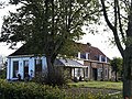 Farm in Eefde
 -
 Villa "Quatre Bras"
 -
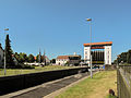
 Eefde, lock photo 1
 -
 Eefde, lock photo 2


References[edit]
- ^ a b c "Kerncijfers wijken en buurten 2021". Central Bureau of Statistics. Retrieved 22 March 2022.
Two entries
- ^ "Postcodetool for 7211AA". Actueel Hoogtebestand Nederland (in Dutch). Het Waterschapshuis. Retrieved 22 March 2022.
- ^ ANWB Topografische Atlas Nederland, Topografische Dienst and ANWB, 2005.
- ^ "Eefde - (geografische naam)". Etymologiebank (in Dutch). Retrieved 22 March 2022.
- ^ "Eefde". Plaatsengids (in Dutch). Retrieved 22 March 2022.
- ^ Ronald Stenvert & Sabine Broekhoven (2000). "Eefde" (in Dutch). Zwolle: Waanders. p. 159. ISBN 90 400 9406 3. Retrieved 22 March 2022.
52°10′N 6°14′E / 52.167°N 6.233°E
This Gelderland location article is a stub. You can help Wikipedia by expanding it. |